Manatuto Municipality
| Manatuto Manatutu | ||
|---|---|---|
| Municipality | ||
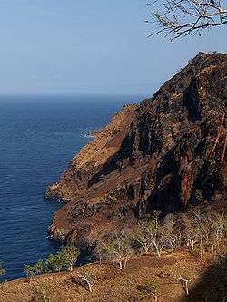 Cliffs at Manatuto | ||
| ||
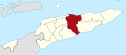 Map of East Timor highlighting Manatuto Municipality | ||
| Coordinates: 8°42′S 125°55′E / 8.700°S 125.917°ECoordinates: 8°42′S 125°55′E / 8.700°S 125.917°E | ||
| Country |
| |
| Capital | Manatuto | |
| Administrative posts | ||
| Area | ||
| • Total | 1,782 km2 (688 sq mi) | |
| Area rank | 2nd | |
| Population (2015 census) | ||
| • Total | 46,619 | |
| • Rank | 13th | |
| • Density | 26/km2 (68/sq mi) | |
| • Density rank | 13th | |
| Households (2015 census) | ||
| • Total | 7,467 | |
| • Rank | 12th | |
| Time zone | UTC+09:00 (TLT) | |
| ISO 3166 code | TL-MT | |

Manatuto (Portuguese: Município Manatuto, Tetum: Munisípiu Manatutu) is one of the municipalities (formerly districts) of East Timor, located in the central part of the country. It has a population of 45,541 (Census 2010) and an area of 1,78 km². The capital of the municipality is also named Manatuto.
Etymology
The word Manatuto is a Portuguese approximation of the local Tetum and Galoli language word Manatutu, which means "pecking birds".[1]
Geography
The borders of the municipality of Manatuto are identical to those of the council of Portuguese Timor with the same name.
The municipality borders the municipalities of Baucau and Viqueque to the east and Manufahi, Aileu, and Dili to the west. It reaches both the south and north coasts of the island, and is only one of two municipalities to do so (the other is Lautém in the far east), and has the most geographical diversity. To the north is the Strait of Wetar, to the south is the Timor Sea.
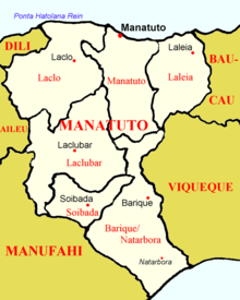
 Administrative posts of Manatuto |
 Cities of Manatuto |
Administrative posts
The municipality's administrative posts (formerly sub-districts) are:[2]
Demographics
In addition to the official languages of East Timor (Tetum and Portuguese), a large part of the population of the municipality speaks the Malayo-Polynesian language Galoli, which is designated as a "national language" by the constitution.
Notable people
The municipality is known as the birthplace of Xanana Gusmão, later to become the nation's first president. He was born in the village of Laleia (19 km East of Manatuto town).
References
- ↑ Hull, Geoffrey (June 2006). "The placenames of East Timor" (PDF). Placenames Australia: Newsletter of the Australian National Placenames Survey: 6–7. Retrieved 4 June 2018.
- ↑ Gunn, Geoffrey C (2011). "Manatuto District". Historical Dictionary of East Timor. Lanham, Maryland: Scarecrow Press. p. 124. ISBN 9780810867543.
External links
![]()