Manandroy
| Manandroy | |
|---|---|
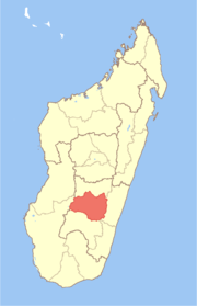
 Manandroy Location in Madagascar | |
| Coordinates: 21°8′S 47°16′E / 21.133°S 47.267°E | |
| Country |
|
| Region | Haute Matsiatra |
| District | Ambohimahasoa |
| Elevation[1] | 1,218 m (3,996 ft) |
| Population (2001)[2] | |
| • Total | 11,000 |
| Time zone | UTC3 (EAT) |
Manandroy is a town and commune in Madagascar. It belongs to the district of Ambohimahasoa, which is a part of Haute Matsiatra Region. The population of the commune was estimated to be approximately 11,000 in 2001 commune census.[2]
Primary and junior level secondary education are available in town. The majority 97% of the population of the commune are farmers. The most important crops are rice and beans, while other important agricultural products are peanuts, cassava, sweet potatoes and bambara groundnut. Services provide employment for 3% of the population.[2]
References and notes
- ↑ Estimated based on DEM data from Shuttle Radar Topography Mission
- 1 2 3 "ILO census data". Cornell University. 2002. Retrieved 2008-05-01.
Coordinates: 21°8′S 47°16′E / 21.133°S 47.267°E
This article is issued from
Wikipedia.
The text is licensed under Creative Commons - Attribution - Sharealike.
Additional terms may apply for the media files.