Malouin River
| Malouin | |
| River | |
| Country | Canada |
|---|---|
| Province | Quebec |
| Region | Nord-du-Québec |
| Source | |
| - location | Eeyou Istchee Baie-James (municipality), Nord-du-Québec, Quebec |
| - elevation | 264 m (866 ft) |
| - coordinates | 50°11′42″N 79°18′00″W / 50.19500°N 79.30000°W |
| Mouth | Turgeon River (Eeyou Istchee Baie-James) |
| - location | Eeyou Istchee Baie-James (municipality), Nord-du-Québec, Quebec |
| - elevation | 34 m (112 ft) |
| - coordinates | 50°42′03″N 79°19′23″W / 50.70083°N 79.32306°WCoordinates: 50°42′03″N 79°19′23″W / 50.70083°N 79.32306°W |
| Length | 67.2 km (41.8 mi) [1] |
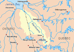 Harricana River basin in yellow | |
The Malouin River is a tributary of the Harricana River, flowing into the municipality of Eeyou Istchee Baie-James (municipality), in the administrative region of Nord-du-Québec, in Quebec, in Canada. Its course crosses the townships of Massicotte and Manthet.
The surface of the river is usually frozen from early November to mid-May, however, safe ice movement is generally from mid-November to the end of April.
Geography
The main hydrographic slopes near the Malouin River are:
- North side: Harricana River, Mannerelle River;
- East side: Harricana River, Breynat River, Despreux River;
- South side: Turgeon River (Eeyou Istchee James Bay), Detour River;
- West side: Again River (Ontario and Quebec), Lawagamau River (Ontario), Mannerelle River.
The Malouin River originates from a forest stream (elevation: 264 metres (866 ft)), in the southern part of the municipality of Eeyou Istchee James Bay (municipality).
The source of the Malouin River is located at:
- 21.5 kilometres (13.4 mi) West of the Harricana River;
- 56.4 kilometres (35.0 mi) South of the mouth of the Malouin River;
- 16.5 kilometres (10.3 mi) Wast of the Ontario border.
From its source, the Malouin River flows more or less parallel to the Ontario border over 67.2 kilometres (41.8 mi) according to the following segments:
- 25.2 kilometres (15.7 mi) North in a marsh zone, up to a bend in the river;
- 17.1 kilometres (10.6 mi) North in a marsh zone, to a creek (coming from the South-East);
- 5.6 kilometres (3.5 mi) North of the marsh zone to the confluence of the Mannerelle River;
- 19.3 kilometres (12.0 mi) North to marsh area to mouth.[2]
The Malouin River flows on the southwestern shore of the Harricana River to:
Toponymy
This hydronym evokes the work of life of the surveyor Paul Malouin (1884-1945), born in Quebec City. The latter undertook studies at the School of Surveying at Laval University in 1904. Received surveyor-surveyor in 1910, he joined the same year with the surveyor Paul Joncas under the enterprise name "Joncas and Malouin".
The designation "Malouin River" is indicated on a regional map of the Abitibi of the Department of Lands and Forests in 1962. In 1895, explorer Henry O'Sullivan named this watercourse "Rivière du Mariage" (English: The River of Marriage) or "Birthday", having discovered him on September 15, 20th anniversary day of his marriage.[3]
The hydronym "Malouin River" was formalized on December 5, 1968 by the Commission de toponymie du Québec, i.e. at the creation of this commission.[4]
Notes and references
- ↑ Atlas of Canada
- ↑ Distances from the Atlas of Canada (published on the Internet) from the Department of Natural Resources Canada.
- ↑ Source: Names and places of Quebec, a work of the "Commission de toponymie du Québec" published in 1994 and 1996 in the form of a printed illustrated dictionary, and under that of a CD-ROM produced by the company Micro -Intel, in 1997, from this dictionary.
- ↑ Commission de toponymie du Québec - Names Bank Place - Place name: "Malouin River"
See also
- Eeyou Istchee Baie-James (municipality), a municipality
- Jamésie, a region
- Harricana River, a watercourse
- Mannerelle River, a watercourse
- James Bay, a body of water
- List of rivers of Quebec