Malgas
| Malgas | |
|---|---|
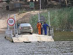 The Malgas cable ferry on the Breede River | |
 Malgas  Malgas Malgas (South Africa)  Malgas Malgas (Africa) | |
| Coordinates: 34°18′00″S 20°34′59″E / 34.3°S 20.583°ECoordinates: 34°18′00″S 20°34′59″E / 34.3°S 20.583°E | |
| Country | South Africa |
| Province | Western Cape |
| District | Overberg |
| Municipality | Swellendam |
| Area[1] | |
| • Total | 0.77 km2 (0.30 sq mi) |
| Population (2011)[1] | |
| • Total | 44 |
| • Density | 57/km2 (150/sq mi) |
| Racial makeup (2011)[1] | |
| • Black African | 11.4% |
| • Coloured | 50.0% |
| • White | 38.6% |
| First languages (2011)[1] | |
| • Afrikaans | 74.4% |
| • English | 18.6% |
| • S. Ndebele | 2.3% |
| • Xhosa | 2.3% |
| • Other | 2.3% |
| Time zone | UTC+2 (SAST) |
Malgas is a settlement on the right (southwest) bank of the Breede River in the Overberg region of the Western Cape. It is situated 25 kilometres north-west of the Breede River mouth at Witsand, and 30 kilometres south-east of Swellendam. The name "Malgas" is probably an adaptation of the Portuguese mangas de velludo, "velvet sleeves", referring to the Cape gannet (Morus capensis) with its black-tipped wings.[2] According to the 2011 census, Malgas has a population of 44 people in 20 households.[1] It is well known for the "pont", a man-hauled pontoon cable ferry across the Breede River, which is the last of its type in South Africa.[3]
References
- 1 2 3 4 5 "Main Place Malgas". Census 2011.
- ↑ Raper, P. E. (1987). Dictionary of South African Place Names. Lowry Publishers. pp. 292–293. ISBN 0947042067.
- ↑ Brooke, Simon (18 April 2013). "However you spell it, Malgas is an oasis". Business Day. Times Media (Pty) Ltd. Archived from the original on 2016-03-03. Retrieved 17 September 2018.
Municipalities and communities of Overberg District Municipality, Western Cape | ||
|---|---|---|
District seat: Bredasdorp | ||
| Cape Agulhas | .svg.png) | |
| Overstrand | ||
| Swellendam | ||
| Theewaterskloof | ||
This article is issued from
Wikipedia.
The text is licensed under Creative Commons - Attribution - Sharealike.
Additional terms may apply for the media files.