Malekhiv
| Malekhiv Малехів | |
|---|---|
| village | |
 | |
 Malekhiv | |
| Coordinates: 49°52′54″N 24°14′31″E / 49.88167°N 24.24194°ECoordinates: 49°52′54″N 24°14′31″E / 49.88167°N 24.24194°E | |
| Country |
|
| Province |
|
| District |
|
| Established | 1377 |
| Area | |
| • Total | 5,79 km2 (224 sq mi) |
| Elevation/(average value of) | 268 m (879 ft) |
| Population | |
| • Total | 3 000 |
| • Density | 403,450/km2 (1,044,900/sq mi) |
| Time zone | UTC+2 (EET) |
| • Summer (DST) | UTC+3 (EEST) |
| Postal code | 80383 |
| Area code | +380 322 |
| Website | село Малехів (Ukrainian) |
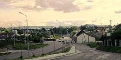
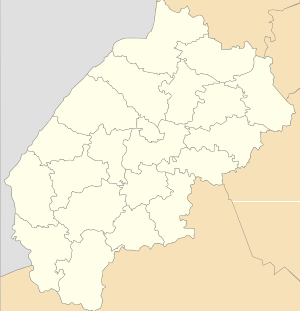
Malekhiv (Ukrainian: Мале́хів[1]) — village in Zhovkva Raion of Lviv region (Lviv Oblast), is located at a distance of 6 kilometres (3.7 mi) northeast of the city Lviv. It is at a distance 29 kilometres (18 mi) from the district center Zhovkva, and 7 kilometres (4.3 mi) from the village Velyki Hrybovychi.
Elevation footnotes (average value of) is 268 metres (880 ft).[2] Local government — Malekhivska village council.[3]
Through the village passes Highway M06 (Ukraine) (![]()
History
The first mention of villages Malekhiv in historical documents refers to 1377.[4] But Ancient people have lived in territory of village Malekhiv in the first century AD.
History of the name — Malechow (Lemberg Umgebung), Galicia, Austria; later Malechow (Lwow), Lwow, Poland; now Malekhiv, Zhovkva, L′viv, Ukraine.[5]
Religious communities
In the village there are three religious communities. This religious community of the Ukrainian Greek Catholic Church, the Roman Catholic Church and Religious Communities Ukrainian Orthodox Autocephalous Church.
There has church Cathedral of the Most Holy Theotokos, which belongs to the Greek Catholic community (the temple was built in 1892), and Catholic church of St. Archangel Michael (was built in 70 years of the 18th century).
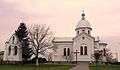 Church Cathedral of the Most Holy Theotokos UGCC.
.JPG) Roman Catholic church of St. Archangel Michael
Roman Catholic church of St. Archangel Michael Temple of Cathedral of the Holy Mother of God Ukrainian UAOC. Malekhiv (Zhovkva Raion).
References
- ↑ Малехів, вікіпедія (in Ukrainian)
- ↑ Google Earth
- ↑ Malekhivska village council Archived 2014-12-10 at the Wayback Machine.
- ↑ Malekhiv village: street map, description Archived 2014-11-02 at Archive.is
- ↑ LDS microfilm list of villages in Zhovkva (aka Nesterov) raion in L'viv oblast
External links
- Малехів - костел св.Архистратига Михаїла (in Ukrainian)
- «Churches and Chapels of Ukraine» (in Polish)
- MALECHÓW. Kościół p.w. św. Michała Archanioła (in Polish)
- Malekhiv Sightseeing Guide