Makra Peak
| Makra Peak | |
|---|---|
 Makra Peak, Shogran | |
| Highest point | |
| Elevation | 3,885 m (12,746 ft) [1] |
| Listing | List of mountains in Pakistan |
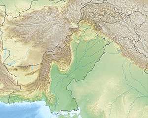
| Coordinates | 34°34′26″N 73°29′43″E / 34.57389°N 73.49528°ECoordinates: 34°34′26″N 73°29′43″E / 34.57389°N 73.49528°E [2] |
| Geography | |
 Makra Peak | |
| Parent range | Himalayas |
| Climbing | |
| Easiest route | Hike |
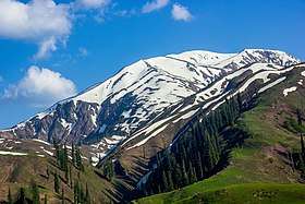
The Makra is a scenic peak in the Mansehra District in Hazara Region of the Himalayas in northern Pakistan. It is 3,885 metres (12,746 ft) high and almost 200 kilometres (120 mi) from Islamabad on the Naran Road.[3] From Kiwai, a single 7-kilometre-long road runs uphill to Shogran, a tourist resort with numerous hotels; the track continues to climb up to Siri Lake and ends at Paye. From here it is a trek of four hours to the top of the Makra. Hiking on the Makra is difficult due to snow and the gradient of the mountainsides.
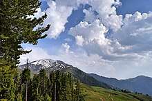
Although it can be straightforward to climb, fatalities have occurred during storms and the fatality rate is 30%. In spite of its difficulties, the summit offers the good views of Hazara and Azad Kashmir. Fatalities tend to occur in bad weather, especially thick fog, and as a result of the steepness of some sections. The waters from the mountain's glacier feed the Kunhar River. The place has been named as Makra Peak by locals as Makra (means spider in Urdu, the local language) due to its shape in snow resembling that of a spider on a web.
See also
References
- ↑ "Makra Peak Elevation". www.summitpost.org. Retrieved 28 September 2018.
- ↑ "Makra on Google Maps". Google Maps. Retrieved 28 September 2018.
- ↑ "Makra Peak, Shogran, Kaghan". www.pakistantoursguide.com. Retrieved 28 September 2018.
External links