Maitai River
| Maitai River | |
|---|---|
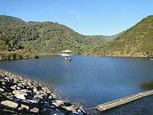 Water behind the dam on the river | |
| Country | New Zealand |
| Physical characteristics | |
| River mouth | Tasman Bay |
| Length | 11 km (7 mi) |
The Maitai / Mahitahi River is an awa (river) of the northwest of New Zealand's South Island. It flows westwards through hill country west of the Bryant Range before passing through the city of Nelson, reaching Tasman Bay at Nelson Haven. Major tributaries of The Maitai River include The Brook, Te Wairepo / York Stream and Sharland Creek.
The Maitai River was dammed in 1987 at the confluence of the southern and northern branches to provide a secure water supply for Nelson City. The Maitai valley features cycling and walking paths, a golf course, and swimming holes for visitors.[1]
A four year project between Nelson City Council and community partners to improve the health of the Maitai River and all its tributaries is summarised in the Project Maitai / Mahitahi story map.
See also
References
- ↑ "Maitai River Ride | Nelson, New Zealand". www.newzealand.com. Retrieved 2018-07-17.
| Wikimedia Commons has media related to Maitai River. |
"Place name detail: Maitai River". New Zealand Gazetteer. Land Information New Zealand. Retrieved 12 July 2009.
Coordinates: 41°16′S 173°17′E / 41.267°S 173.283°E