Maine State Route 209
| ||||
|---|---|---|---|---|
 | ||||
| Route information | ||||
| Maintained by MaineDOT | ||||
| Length | 15.92 mi[1] (25.62 km) | |||
| Major junctions | ||||
| South end | Dead end in Phippsburg | |||
|
| ||||
| North end |
| |||
| Location | ||||
| Counties | Sagadahoc | |||
| Highway system | ||||
| ||||

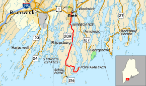
State Route 209 (SR 209) is a state route in the U.S. state of Maine. It runs from the intersection of Popham Road and Sea Street in the Phippsburg community of Popham Beach to an interchange with U.S. Route 1 (US 1) in Bath. The entire route is in Sagadahoc County. At its southern end, state maintenance of Popham Road continues past Sea Street to the entrance to Fort Popham.[2]
Junction List
The entire route is in Sagadahoc County.
| Location | mi[1] | km | Destinations | Notes | |
|---|---|---|---|---|---|
| Phippsburg | 0.00 | 0.00 | Popham Road / Sea Street – Fort Popham | ||
| 4.65 | 7.48 | Northern terminus of SR 216 | |||
| Bath | 15.89– 15.92 | 25.57– 25.62 | Interchange; US 1 northbound exit / US 1 southbound entrance only | ||
| 1.000 mi = 1.609 km; 1.000 km = 0.621 mi | |||||
References
- 1 2 Maine DOT Map Viewer (Map). Maine Office of GIS. Retrieved October 15, 2017.
- ↑ Google (October 15, 2017). "Maine State Route 209" (Map). Google Maps. Google. Retrieved October 15, 2017.
External links
This article is issued from
Wikipedia.
The text is licensed under Creative Commons - Attribution - Sharealike.
Additional terms may apply for the media files.