Maine State Route 207
| ||||
|---|---|---|---|---|
| Black Point Road | ||||
 | ||||
| Route information | ||||
| Maintained by MaineDOT | ||||
| Length | 2.93 mi[1] (4.72 km) | |||
| Major junctions | ||||
| South end |
| |||
| North end |
| |||
| Location | ||||
| Counties | Cumberland | |||
| Highway system | ||||
| ||||

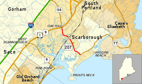
State Route 207 (SR 207) is a short state highway through the town of Scarborough, Maine. It connects Center Scarborough to the coastline at Prouts Neck. For its entire 2.93-mile (4.72 km) length, it is called Black Point Road. The entire route is in Cumberland County.
Major junctions
The entire route is in Scarborough, Cumberland County.
| mi[1] | km | Destinations | Notes | ||
|---|---|---|---|---|---|
| 0.00 | 0.00 | Southern terminus of SR 77 | |||
| 2.93 | 4.72 | Southern terminus of SR 114 | |||
| 1.000 mi = 1.609 km; 1.000 km = 0.621 mi | |||||
References
- 1 2 "MaineDOT - Map Viewer". Retrieved January 21, 2013.
External links
Route map:
This article is issued from
Wikipedia.
The text is licensed under Creative Commons - Attribution - Sharealike.
Additional terms may apply for the media files.