Maine State Route 168
| ||||
|---|---|---|---|---|
| Winn Road | ||||
 | ||||
| Route information | ||||
| Maintained by MaineDOT | ||||
| Length | 10.19 mi[1] (16.40 km) | |||
| Existed | 1925 – present | |||
| Major junctions | ||||
| South end |
| |||
| North end |
| |||
| Location | ||||
| Counties | Penobscot | |||
| Highway system | ||||
| ||||

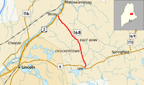
State Route 168 (SR 168) is part of Maine's system of numbered state highways. It runs 10.2 miles (16.4 km) from an intersection with SR 6 in the town of Lee to U.S. Route 2 in Winn. It is known as Winn Road for its entire length.[2]
Major junctions
The entire route is in Penobscot County.
| Location | mi[1] | km | Destinations | Notes | |
|---|---|---|---|---|---|
| Lee | 0.00 | 0.00 | |||
| Winn | 10.19 | 16.40 | |||
| 1.000 mi = 1.609 km; 1.000 km = 0.621 mi | |||||
References
- 1 2 "Maine DOT Map Viewer". Maine Office of GIS. Retrieved August 7, 2017.
- ↑ Google (August 7, 2017). "Maine State Route 168" (Map). Google Maps. Google. Retrieved August 7, 2017.
External links
This article is issued from
Wikipedia.
The text is licensed under Creative Commons - Attribution - Sharealike.
Additional terms may apply for the media files.