Maine Prairie, California
Maine Prairie is an unincorporated community located in Solano County, California east of Elmira, California on the Maine Prairie Slough at latitude 38.308 and longitude -121.759. The elevation is 7 feet (2.1 m). Maine Prairie appears on the Dozier U.S. Geological Survey Map.
During the American Civil War, it was a township large enough to support a California Militia Company (the Maine Prairie Rifles) from Sept. 19, 1863 to June 23, 1868. The township appears on an 1890 map of Solano County.[1]
References
External links
- County Maps - SOLANO COUNTY CALIFORNIA (CA/VACAVILLE) MAP 1877 Shows Original Townships of: Silveyville, Green Valley, Tremont, Vallejo, Benicia, Vacaville, Elmira, Maine Prairie, Denverton, Rio Vista, Suisun, Montezuma, Mount Markley, Potrero Hills, California and Pacific Railroad, Vaca Valley Railroad, Pleasant Valley, Lagoon Valley, Wooden Valley, Sweeny Creek & Prospect Slough.
- Maine Prairie Map — Satellite Images of Maine Prairie
Coordinates: 38°18′29″N 121°45′32″W / 38.30806°N 121.75889°W
Municipalities and communities of Solano County, California, United States | ||
|---|---|---|
| Cities | 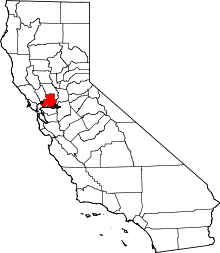 | |
| CDPs | ||
| Unincorporated communities |
| |
| Ghost towns |
| |
This article is issued from
Wikipedia.
The text is licensed under Creative Commons - Attribution - Sharealike.
Additional terms may apply for the media files.