Mailly-le-Château
| Mailly-le-Château | |
|---|---|
| Commune | |
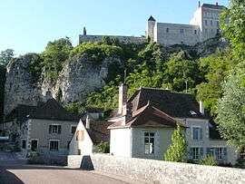 The village from the River Yonne | |
 Mailly-le-Château Location within Bourgogne-Franche-Comté region  Mailly-le-Château | |
| Coordinates: 47°35′49″N 3°38′11″E / 47.5969°N 3.6364°ECoordinates: 47°35′49″N 3°38′11″E / 47.5969°N 3.6364°E | |
| Country | France |
| Region | Bourgogne-Franche-Comté |
| Department | Yonne |
| Arrondissement | Auxerre |
| Canton | Joux-la-Ville |
| Area1 | 37.28 km2 (14.39 sq mi) |
| Population (2006)2 | 597 |
| • Density | 16/km2 (41/sq mi) |
| Time zone | UTC+1 (CET) |
| • Summer (DST) | UTC+2 (CEST) |
| INSEE/Postal code | 89238 /89660 |
| Elevation | 117–254 m (384–833 ft) |
|
1 French Land Register data, which excludes lakes, ponds, glaciers > 1 km2 (0.386 sq mi or 247 acres) and river estuaries. 2 Population without double counting: residents of multiple communes (e.g., students and military personnel) only counted once. | |
Mailly-le-Château is a commune in the Yonne department in Bourgogne-Franche-Comté in north-central France. The lower village is on the left bank of the River Yonne, adjacent to the Canal du Nivernais. The upper village is noted for its 14th-century fortified castle and the 13th-century church of St Adrian.
See also
References
Gallery
 14th-century castle keep
 St Adrian's Church (13th century)
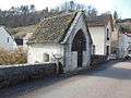 St Nicholas' Chapel (15th century)
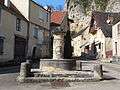 Fontaine au Loup
 A hotel barge on the Nivernais Canal
| Wikimedia Commons has media related to Mailly-le-Château. |
This article is issued from
Wikipedia.
The text is licensed under Creative Commons - Attribution - Sharealike.
Additional terms may apply for the media files.