Mahi Bajaj Sagar Dam
| Mahi Bajaj Sagar Dam | |
|---|---|
 Location of Mahi Bajaj Sagar Dam in Rajasthan  Mahi Bajaj Sagar Dam (India) | |
| Country | India |
| Location | Banswara |
| Coordinates | 23°37′37.31″N 74°32′39.03″E / 23.6270306°N 74.5441750°ECoordinates: 23°37′37.31″N 74°32′39.03″E / 23.6270306°N 74.5441750°E |
| Purpose | Power, irrigation, water storage |
| Status | Operational |
| Construction began | 1972 |
| Opening date | 1983 |
| Dam and spillways | |
| Type of dam | Masonry with embankment main sections |
| Impounds | Mahi River |
| Height | 43 m (141 ft) |
| Length | 3,062 m (10,046 ft) |
| Reservoir | |
| Active capacity | 2,070,000,000 m3 (1,680,000 acre⋅ft) |
| Catchment area | 6,149 km2 (2,374 sq mi) |
| Commission date | 1986, 1989 |
| Turbines | 2 x 25 MW, 2 x 45 MW Francis-type |
| Installed capacity | 140 MW |
Mahi Bajaj Sagar Dam is a dam across the Mahi River. It is situated 16 kilometres from Banswara town in Banswara district Rajasthan, India.[1] The dam was constructed between 1972 and 1983 for the purposes of hydroelectric power generation and water supply. It is the second largest dam in Rajasthan. It is named after Jamnalal Bajaj.[2][3]
Power Plant
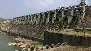
Mahi Bajaj Sagar Dam
The dam has an installed capacity of 140 MW.[4]
| Stage | Unit Number | Installed Capacity (MW) | Date of Commissioning | Status |
|---|---|---|---|---|
| 1 | 1 | 25 | 1986 January | Operational |
| 1 | 2 | 25 | 1986 February | Operational |
| 2 | 1 | 45 | 1989 February | Operational |
| 2 | 2 | 45 | 1989 September | Operational |
See also
- Kadana Dam – located downstream
References
- ↑ "Archived copy". Archived from the original on 2014-06-26. Retrieved 2014-03-21.
- ↑ "Hydroelectric Power Plants in India - Madhya Pradesh & Rajasthan". IndustCards. Retrieved 24 March 2014.
- ↑ "Water Resources Development Projects in the Mahi Basin". National Institute of Hydrology Roorkee. Archived from the original on 11 February 2012. Retrieved 24 March 2014.
- ↑ http://www.rvunl.com/Mahi%20hydel%20power%20station.php
This article is issued from
Wikipedia.
The text is licensed under Creative Commons - Attribution - Sharealike.
Additional terms may apply for the media files.