Maherivaratra
| Maherivaratra | |
|---|---|
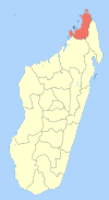
 Maherivaratra Location in Madagascar | |
| Coordinates: 13°30′S 48°40′E / 13.500°S 48.667°E | |
| Country |
|
| Region | Diana |
| District | Ambanja |
| Elevation[1] | 15 m (49 ft) |
| Population (2001)[2] | |
| • Total | 4,151 |
| Time zone | UTC3 (EAT) |
Maherivaratra is a municipality (French: commune, Malagasy: kaominina) in Madagascar. It belongs to the district of Ambanja, which is a part of Diana Region. According to 2001 census the population of Maherivaratra was 4,151.[2]
Maherivaratra is served by a local airport. Only primary schooling is available in town. The majority 59% of the population are farmers. The most important crop is seeds of catechu, while other important products are coffee and rice. Services provide employment for 1% and fishing employs 40% of the population.[2]
References and notes
- ↑ Estimated based on DEM data from Shuttle Radar Topography Mission
- 1 2 3 "ILO census data". Cornell University. 2002. Retrieved 2008-02-13.
| Ambanja |
|  |
|---|---|---|
| Ambilobe | ||
| Antsiranana I | ||
| Antsiranana II | ||
| Nosy Be | ||
Coordinates: 13°30′S 48°40′E / 13.500°S 48.667°E
This article is issued from
Wikipedia.
The text is licensed under Creative Commons - Attribution - Sharealike.
Additional terms may apply for the media files.