Maggies Peaks
| Maggies Peaks | |
|---|---|
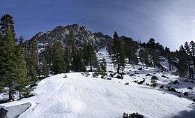 Maggies Peaks as seen from the south | |
| Highest point | |
| Peak | Maggies Peaks (South) |
| Elevation | 8,703 ft (2,653 m) NAVD 88[1] |
| Prominence | 579 ft (176 m) [1] |
| Coordinates | 38°55′54″N 120°06′50″W / 38.9315744°N 120.1137971°WCoordinates: 38°55′54″N 120°06′50″W / 38.9315744°N 120.1137971°W [2] |
| Geography | |
| Location | El Dorado County, California, U.S. |
| Parent range | Sierra Nevada |
| Topo map | USGS Emerald Bay |
| Climbing | |
| Easiest route | class 1-2 |
Maggie's Peaks refers to a mountain in the Sierra Nevada mountain range, to the west of Lake Tahoe. There are two peaks on the mountain. The northern peak has an elevation of about 8,499 feet (2,590 m)[3] and is about 0.7 miles (1 km) north of the main peak. The mountain is located in the Desolation Wilderness in El Dorado County, California. The summits overlook Lake Tahoe and affords very good views of the lake.
References
- 1 2 "Maggies Peaks-South Summit, California". Peakbagger.com. Retrieved 2009-08-08.
- ↑ "Maggies Peaks". Geographic Names Information System. United States Geological Survey. Retrieved 2009-08-08.
- ↑ "Maggies Peaks-North Summit, California". Peakbagger.com. Retrieved 2016-04-01.
External links
- "Granite Lake and Maggies Peaks". Tahoe Adventure Sports.
- "Maggies Peaks". SummitPost.org.
This article is issued from
Wikipedia.
The text is licensed under Creative Commons - Attribution - Sharealike.
Additional terms may apply for the media files.