English Maelor
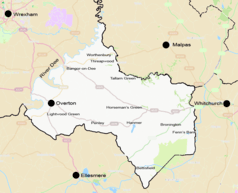
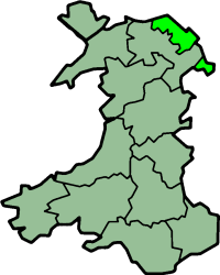
English Maelor (Welsh: Maelor Saesneg) comprises one half of the Maelor region located on the Wales-England border, considered to be the area east of the River Dee. The region has changed counties several times, previously being part of Cheshire and later a detached portion of Flintshire.[1] The area is currently administered as part of Wrexham County Borough.
History
At the time of the Roman invasion, the area was part of the region occupied by the Cornovii, one of the Celtic tribes of ancient Britain, on the border with the Deceangli tribe across the River Dee to the west. Following Roman Britain, and the emergence of various petty kingdoms, the region was ruled within the Kingdom of Powys until falling to the Kingdom of Mercia by the late 8th century under Aethelbald. By the time of the Domesday book (1086) the Earldom of Mercia had been abolished and become the Earldom of Chester, and the region is listed as part of the Cheshire Hundred of Duddestan, with Bettisfield being the largest settlement with 28 households.[2]
The English Maelor is first recorded as a separate lordship from the Maelor in 1202.[3] It was inherited by Gruffydd Maelor II in 1236 when his father, Madog ap Gruffydd Maelor, died and his kingdom was divided between his five sons. Gruffydd married Emma Audley of Shropshire. Emma was dispossessed of the lands by Llywelyn the Great upon the death of Gruffudd in 1269.
Llywelyn ap Gruffudd surrendered the English Maelor to Edward I in 1282 following military campaigns, Edward then awarded them to Queen Eleanor. In 1309, under Edward II, the English Maelor was granted to Queen Isabella. In 1397, under Richard II of England, it was merged with the County Palatine of Chester to form the Principality of Chester, but was reduced to an earldom again the following year by Henry IV.
In 1536, under the rule of Henry VIII, the area was included into the county of Flintshire, forming the Hundred of Maelor. Although part of Flintshire, Maelor Hundred was an exclave, surrounded by Cheshire, Shropshire and Denbighshire. The administrative centre of the area, often referred to as Flintshire Detached, was Overton and it included the villages of Bangor on Dee, Bettisfield, Bronington, Hanmer, Knolton, Penley, Tybroughton, Willington and Worthenbury. An OS map specifically including the area, dating from 1905, is available from Old Ordnance Survey Maps (Sheet 122) entitled "Whitchurch, Nantwich and English Maelor".
In 1887 a Boundary Commission was appointed to review the boundaries of counties in England and Wales. At an inquiry at Overton, it was found that most of the population of the area favoured it becoming part of Shropshire, and this was later supported by resolution of the Flintshire justices of the peace.[4] However, when local government legislation was introduced no change was made.
Under the Local Government Act 1894 the area became Overton Rural District. The administrative county of Flintshire was abolished in 1974 under the Local Government Act 1972, and the area became part of Clwyd. Since Clywd was itself abolished in 1996 under the Local Government (Wales) Act 1994, the area has been administered as part of Wrexham County Borough.
References
Remfry, P.M., Whittington Castle and the families of Bleddyn ap Cynfyn, Peverel, Maminot, Powys and Fitz Warin ( ISBN 1-899376-80-1)