Madaket, Massachusetts
| Madaket | |
|---|---|
| CDP | |
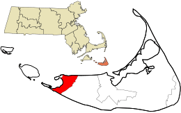 Location in Nantucket County and the state of Massachusetts. | |
| Coordinates: 41°16′22″N 70°11′53″W / 41.27278°N 70.19806°WCoordinates: 41°16′22″N 70°11′53″W / 41.27278°N 70.19806°W | |
| Country | United States |
| State | Massachusetts |
| County | Nantucket |
| Elevation | 26 ft (8 m) |
| Time zone | UTC-5 (Eastern (EST)) |
| • Summer (DST) | UTC-4 (EDT) |
| GNIS feature ID | 616708[1] |
Madaket (also Madaquet, Maddaket, Maddequet, Madeket, or Mattaket) is a census designated place (CDP) in Nantucket, Massachusetts, United States. Its elevation is 26 feet (8 m) on the western end of the island. The various spellings of its name led the Board on Geographic Names to designate its official spelling in 1966.[1] It is also home to the Madaket Ditch, one of the earliest public works projects in America.
References
- 1 2 "Madaket, Massachusetts". Geographic Names Information System. United States Geological Survey. Retrieved 29 January 2008.
Municipalities and communities of Nantucket County, Massachusetts, United States | ||
|---|---|---|
| Town | 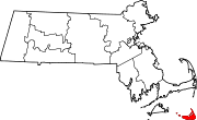 | |
| CDPs | ||
| Other villages | ||
This article is issued from
Wikipedia.
The text is licensed under Creative Commons - Attribution - Sharealike.
Additional terms may apply for the media files.