Mabel Island
| Geography | |
|---|---|
| Location | Northern Australia |
| Coordinates | 17°12′36″S 146°04′41″E / 17.210°S 146.078°ECoordinates: 17°12′36″S 146°04′41″E / 17.210°S 146.078°E |
| Area | 0.03 km2 (0.012 sq mi) |
| Administration | |
| State | Queensland |
Mabel Island in North Queensland, Australia is part of the Frankland Islands 30 km north-east of Babinda, and south-west of Cairns. It is around 3 hectares or 0.03 square km in size.[1]
The Frankland Islands are teeming with permanent and migratory marine life, especially the Green Sea Turtle which nests on the island. Normanby Island, part of the Frankland Islands group offers a comprehensive reef system with a tropical island.
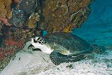
A Green Sea Turtle(Chelonia mydas)
The islands are very popular with reef tour operators working from Cairns.
References
This article is issued from
Wikipedia.
The text is licensed under Creative Commons - Attribution - Sharealike.
Additional terms may apply for the media files.