Múlakvísl
| Múlakvísl | |
|---|---|
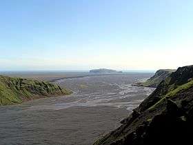 A view of the Múlakvísl, looking towards Hjörleifshöfði in the background and the Atlantic Ocean | |
| Country | Iceland |
| Region | Southern Region |
| Physical characteristics | |
| Main source |
Mýrdalsjökull 63°37′50″N 19°53′00″W / 63.6306°N 19.8834°W |
| River mouth |
Between Vík í Mýrdal and Mýrdalssandur 63°24′00″N 18°53′00″W / 63.4°N 18.8834°WCoordinates: 63°24′00″N 18°53′00″W / 63.4°N 18.8834°W |
| Basin features | |
| River system | Múlakvísl |
The Múlakvísl is a river in the south of Iceland on the western side of Mýrdalssandur.
Glacier flow
The river has a glacier flow which draws its water from the Mýrdalsjökull, mainly through the glacier tongue Kötlujökull. The river's floods are usually of gray-brown color, since it carries much sediment with it.[1]
At Selfjall, about 10 km (6.2 mi) east of the village Vík í Mýrdal, the Ring Road goes across a bridge over the Múlakvísl.
Jökulhlaups
As increasing water levels of this river are an important indicator of Katla's upcoming volcanic eruptions, it is closely monitored.
1955
A predecessor of the present bridge was demolished in 1955, during a jökulhlaup with 2500 m³/s of water. A fissure formed on Katla in 1918 in the caldera of the volcano, and a kettle had formed upon the glacier. This showed volcanic activities under the glacier, which in turn initiated the jökulhlaup. However, there was no real outbreak in 1955.[1]
July 2011
On 9 July 2011, another jökulhlaup occurred, which was already expected hours and days before due to a series of quakes at up to 10 km (6.2 mi) depth in the Katla region.[2][3] There was a small volcanic eruption under the glacier similar to 1955.[4]
A jökulhlaup again destroyed the Ring Road bridge of the Múlakvísl, which was only 20 years old. Due to a jökulhlaup warning by a water level early warning system, the road was blocked for traffic about an hour before the destruction of the bridge, so no one was harmed.[5] By 11 July 2011, the tremor under Katla had calmed down again. On 15 July 2011, 1,500 people were transported via the Múlakvísl by means of special vehicles.[6] On 16 July a temporary bridge was put into operation on the river.[7]
See also
References
| Wikimedia Commons has media related to Múlakvísl. |
- 1 2 Einarsson, Hg. T.; Magnússon, H. (1989). Íslandshandbókin. Náttúra, saga og sérkenni [Iceland Handbook. Nature, history and characteristics] (in Icelandic). 2. Reykjavík: Örn og Örlygur. p. 709.
- ↑ "May 2011". Veðurstofa Íslands (in Icelandic). Retrieved 24 December 2016.
- ↑ "Jarðskjálftar 20110704 - 20110710, vika 27". Veðurstofa Íslands (in Icelandic). Archived from the original on 17 July 2011. Retrieved 24 December 2016.
- ↑ "Bulletin Reports - Index". Smithsonian Institution. Archived from the original on 13 July 2014. Retrieved 24 December 2016.
- ↑ "Gos hugsanlega hafið". mbl.is (in Icelandic). 9 July 2011. Retrieved 24 December 2016.
- ↑ "Brúin yfir Múlakvísl opnuð á morgun". RÚV (in Icelandic). 15 July 2011. Archived from the original on 17 July 2011.
- ↑ "Fylktu liði yfir brú". mbl.is (in Icelandic). 16 July 2011. Retrieved 24 December 2016.