Mære
| Mære | |
|---|---|
| Village | |
 Mære Location of the village  Mære Mære (Norway) | |
| Coordinates: 63°56′17″N 11°25′34″E / 63.9380°N 11.4260°ECoordinates: 63°56′17″N 11°25′34″E / 63.9380°N 11.4260°E | |
| Country | Norway |
| Region | Central Norway |
| County | Trøndelag |
| District | Innherred |
| Municipality | Steinkjer |
| Area[1] | |
| • Total | 0.35 km2 (0.14 sq mi) |
| Elevation[2] | 43 m (141 ft) |
| Population (2017)[1] | |
| • Total | 449 |
| • Density | 1,283/km2 (3,320/sq mi) |
| Time zone | UTC+01:00 (CET) |
| • Summer (DST) | UTC+02:00 (CEST) |
| Post Code | 7710 Sparbu |
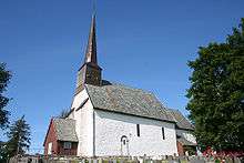
Mære is a village in the municipality of Steinkjer in Trøndelag county, Norway. It is located along European route E6 and the Nordlandsbanen railway line, about 10 kilometres (6.2 mi) south of the town of Steinkjer. The village of Sparbu lies about 2.5 kilometres (1.6 mi) south of Mære. Mære Church is located in this village as well.[3]
The 0.35-square-kilometre (86-acre) village has a population (2017) of 449 which gives the village a population density of 1,283 inhabitants per square kilometre (3,320/sq mi).[1]
History
In the early Viking Age, according to the Sagas, Mære was one of the most important religious ceremonial places, with sacrifices to the Norse gods. Under the medieval church at Mære, traces of preceding heathen hof were found in archeological investigations during the 1960s, the only case in Norway so far of a pre-Christian building being found to have existed on the site of a church.
References
- 1 2 3 Statistisk sentralbyrå (1 January 2017). "Urban settlements. Population and area, by municipality".
- ↑ "Mære, Steinkjer (Trøndelag)". yr.no. Retrieved 2018-04-08.
- ↑ Rosvold, Knut A., ed. (2018-02-05). "Mære". Store norske leksikon (in Norwegian). Kunnskapsforlaget. Retrieved 2018-04-08.