Lyubimets Nunatak
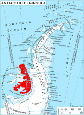
Lyubimets Nunatak (Bulgarian: нунатак Любимец, ‘Nunatak Lyubimets’ \'nu-na-tak lyu-'bi-mets\) is the partly ice-covered rocky ridge extending 3.9 km in north-northeast to south-southwest direction and 1.8 km wide, rising to 1100 m in Bartók Glacier on the west side of Elgar Uplands in northern Alexander Island, Antarctica. The feature is named after the town of Lyubimets in Southern Bulgaria.
Location
The ridge is located at 69°42′37″S 70°57′46″W / 69.71028°S 70.96278°WCoordinates: 69°42′37″S 70°57′46″W / 69.71028°S 70.96278°W, which is 6.27 km northwest of Mount Pinafore, 5.62 km northeast of Appalachia Nunataks and 3.9 km south-southwest of Kozhuh Peak.
Maps
- British Antarctic Territory. Scale 1:200000 topographic map. DOS 610 – W 69 70. Tolworth, UK, 1971
- Antarctic Digital Database (ADD). Scale 1:250000 topographic map of Antarctica. Scientific Committee on Antarctic Research (SCAR). Since 1993, regularly upgraded and updated
References
- Bulgarian Antarctic Gazetteer. Antarctic Place-names Commission. (details in Bulgarian, basic data in English)
- Lyubimets Nunatak. SCAR Composite Gazetteer of Antarctica
This article includes information from the Antarctic Place-names Commission of Bulgaria which is used with permission.