Lysøysundet
| Lysøysundet | |
|---|---|
| Village | |
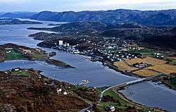 View of the village | |
 Lysøysundet Location of the village  Lysøysundet Lysøysundet (Norway) | |
| Coordinates: 63°53′05″N 9°51′51″E / 63.8846°N 09.8643°ECoordinates: 63°53′05″N 9°51′51″E / 63.8846°N 09.8643°E | |
| Country | Norway |
| Region | Central Norway |
| County | Trøndelag |
| District | Fosen |
| Municipality | Bjugn |
| Area[1] | |
| • Total | 0.4 km2 (0.2 sq mi) |
| Elevation[2] | 15 m (49 ft) |
| Population (2017)[1] | |
| • Total | 276 |
| • Density | 690/km2 (1,800/sq mi) |
| Time zone | UTC+01:00 (CET) |
| • Summer (DST) | UTC+02:00 (CEST) |
| Post Code | 7168 Lysøysundet |
Lysøysundet is a village in the municipality of Bjugn in Trøndelag county, Norway. The village is located in the northern part of the municipality near the island of Lauvøya and the end of the Åfjorden. It is about 5 kilometres (3.1 mi) northeast of the village of Jøssund. The village lies on the mainland and on the nearby island of Lysøya which is connected by a bridge.
The 0.4-square-kilometre (99-acre) village has a population (2017) of 276 which gives the village a population density of 690 inhabitants per square kilometre (1,800/sq mi).[1] The village is divided into several areas: Lysøya, Rømmen, Hellesvika, Tiltrem, Olden, Teksdal, and Sundet. Lysøysundet has an elementary school, kindergarten, and a nursing home.
References
- 1 2 3 Statistisk sentralbyrå (1 January 2017). "Urban settlements. Population and area, by municipality".
- ↑ "Lysøysundet, Bjugn (Trøndelag)". yr.no. Retrieved 2018-03-01.
| Authority control |
|---|
This article is issued from
Wikipedia.
The text is licensed under Creative Commons - Attribution - Sharealike.
Additional terms may apply for the media files.