Lybid River
| Lybid River | |
|---|---|
 | |
| Country | Ukraine |
| Physical characteristics | |
| River mouth | Dnieper |
| Length | 16 km (9.9 mi) |
| Basin features | |
| Basin size | 68 km2 (26 sq mi) |
The Lybid (Ukrainian: Либідь) is a small river in Kiev, Ukraine. A right tributary of the Dnieper, it flows within the "Right Bank" (original) part of the city, just to the west of the historic center. The Lybid has played an important role in shaping Kiev's urban d in aiding the city's drainage system.
Course
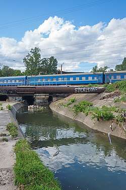
The Lybid runs east, then southeast, then roughly parallel to the Dnieper before it takes a sharp eastward turn and enters the Dnieper several kilometers south of Kiev's center. The river travels through a culvert for much of its course. It can be seen along the railway lines south-east from the main station of Kiev.
The Lybid has small tributaries, most notably the Khreschatyk River. It runs parallel to modern Kiev's main street, Khreschatyk. Another notable tributary, with small lakes on its course, joins just as the Lybid turns to the east in the Montajnik area south of central Kiev.
Name
The river was named after the possibly mythical Lybid, sister of the legendary founders of Kiev, Kyi, Schek, and Khoryv. Others state that Lybid was a former ruler of the Kyiv prior to times of Kievan Rus'.
History
References to the Lybid River were first made in records in 968 A.D. The Lybid was then a relatively big river, as deep as 20 meters in some places. It formed the southern boundary of the city.[1][2]
In the 19th century, the river was widely used for milling. In some places, it reached up to 50 meters across. Three watermills were situated on one of these wide sections where the river formed a reservoir with small islands on it. The biggest watermill was Mikhaylivska. Seven watermills lined the river. Due to the milling business, the surrounding area began to develop, with inns and small villages. Late in the 19th century, construction of the railway began.
Twenty-first century
Lybid is no more than half a meter deep and does not exceed four meters in width. Its course now is mostly subterranean, flowing through concrete pipes, growing polluted as it flows past the town's industrial areas.[1]
References
- 1 2 "The mystery of the Lybid River". Kyiv Guide. Retrieved 22 July 2013.
- ↑ "The mystery of the Lybid River". Kyiv Post. 5 November 2008. Retrieved 24 October 2017.
Coordinates: 50°26′47″N 30°24′37″E / 50.44639°N 30.41028°E