Lutowiska
| Lutowiska | ||
|---|---|---|
| Village | ||
 Lutowiska | ||
| ||
 Lutowiska | ||
| Coordinates: 49°15′4″N 22°41′45″E / 49.25111°N 22.69583°E | ||
| Country |
| |
| Voivodeship | Subcarpathian | |
| County | Bieszczady | |
| Gmina | Lutowiska | |
| Population | 750 | |
.jpg)
The Catholic Church of St. Stanislaus. Built between 1911-1914.
Lutowiska [lutɔˈvʲiska] (Ukrainian: Літовищі, Litovyshchi; 1944-1957: Shevchenko/Szewczenko) is a village in Bieszczady County, in the Subcarpathian Voivodeship of south-eastern Poland, close to the border with Ukraine.
It is the seat of the gmina (administrative district) called Gmina Lutowiska. It lies approximately 22 kilometres (14 mi) south of Ustrzyki Dolne and 101 km (63 mi) south-east of the regional capital Rzeszów.[1]
The village has a population of 750.

See also
References
Coordinates: 49°15′4″N 22°41′45″E / 49.25111°N 22.69583°E

The seat of the municipality Lutowiska
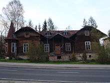
The building of the early twentieth century. Initially housed Hotel Penera later Jewish school. After the war the facility WOP (Communist Border Guard).
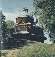
Orthodox Church of Archangel Michael built in 1898. Demolished in 1980. With these materials was established church in Dwernik.
| Seat |  | |
|---|---|---|
| Other villages | ||
| Wikimedia Commons has media related to Lutowiska. |
This article is issued from
Wikipedia.
The text is licensed under Creative Commons - Attribution - Sharealike.
Additional terms may apply for the media files.