Lugagnano Val d'Arda
| Lugagnano Val d'Arda | |
|---|---|
| Comune | |
| Comune di Lugagnano Val d'Arda | |
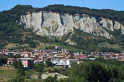 | |
 Lugagnano Val d'Arda Location of Lugagnano Val d'Arda in Italy | |
| Coordinates: 44°49′N 9°49′E / 44.817°N 9.817°E | |
| Country | Italy |
| Region | Emilia-Romagna |
| Province | Piacenza (PC) |
| Frazioni | Antognano, Chiavenna Rocchetta, Diolo, Montezago, Prato Ottesola, Rustigazzo, Tabiano, Velleia, Vicanino |
| Government | |
| • Mayor | Jonathan Papamarenghi |
| Area | |
| • Total | 54.4 km2 (21.0 sq mi) |
| Elevation | 229 m (751 ft) |
| Population (30 September 2017.[1]) | |
| • Total | 3,997 |
| • Density | 73/km2 (190/sq mi) |
| Demonym(s) | Lugagnanesi |
| Time zone | UTC+1 (CET) |
| • Summer (DST) | UTC+2 (CEST) |
| Postal code | 29018 |
| Dialing code | 0523 |
| Website | Official website |
Lugagnano Val d'Arda (Piacentino: Lügagnan) is a comune (municipality) in the Province of Piacenza in the Italian region Emilia-Romagna, located about 130 kilometres (81 mi) northwest of Bologna and about 30 kilometres (19 mi) southeast of Piacenza, on the Arda stream.
Lugagnano Val d'Arda borders the following municipalities: Carpaneto Piacentino, Castell'Arquato, Gropparello, Morfasso, Vernasca.
References
External links


| Authority control |
|---|
This article is issued from
Wikipedia.
The text is licensed under Creative Commons - Attribution - Sharealike.
Additional terms may apply for the media files.