Carpaneto Piacentino
| Carpaneto Piacentino | |
|---|---|
| Comune | |
| Comune di Carpaneto Piacentino | |
 | |
 Carpaneto Piacentino Location of Carpaneto Piacentino in Italy | |
| Coordinates: 44°55′N 9°47′E / 44.917°N 9.783°ECoordinates: 44°55′N 9°47′E / 44.917°N 9.783°E | |
| Country | Italy |
| Region | Emilia-Romagna |
| Province | Piacenza (PC) |
| Frazioni | Zena, Celleri, Ciriano, Chero, Cimafava, Viustino, Travazzano, Badagnano, Rezzano, Magnano, Montanaro |
| Government | |
| • Mayor | Andrea Arfani |
| Area | |
| • Total | 63.2 km2 (24.4 sq mi) |
| Elevation | 400 m (1,300 ft) |
| Population (31 May 2017)[1] | |
| • Total | 7,740 |
| • Density | 120/km2 (320/sq mi) |
| Demonym(s) | Carpanetesi |
| Time zone | UTC+1 (CET) |
| • Summer (DST) | UTC+2 (CEST) |
| Postal code | 29013 |
| Dialing code | 0523 |

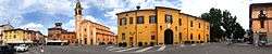
piazza

The Castle
Carpaneto Piacentino (Piacentino: Carpané) is a comune (municipality) in the Province of Piacenza in the Italian region of Emilia-Romagna, located about 130 kilometres (81 mi) northwest of Bologna and about 15 kilometres (9 mi) southeast of Piacenza.
Sights include the Badagnano Castle and the Olmeto Castle, both located in the frazione of Badagnano.
Carpaneto Piacentino borders the following municipalities: Cadeo, Castell'Arquato, Fiorenzuola d'Arda, Gropparello, Lugagnano Val d'Arda, Pontenure, San Giorgio Piacentino.
References
External links


| Authority control |
|---|
This article is issued from
Wikipedia.
The text is licensed under Creative Commons - Attribution - Sharealike.
Additional terms may apply for the media files.