Lubec - Campobello Border Crossing
| Lubec - Campobello Border Crossing | |
|---|---|
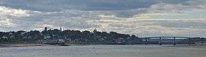 International Boundary and FDR Bridge connecting Lubec ME with Campobello Island, NB | |
| Location | |
| Country | United States; Canada |
| Location |
US Port: 9 Washington Street, Lubec, Maine 04652 Canadian Port: 1 Route 774, Welshpool NB E5E 1A1 |
| Coordinates | 44°51′34″N 66°58′48″W / 44.859398°N 66.980016°W |
| Details | |
| Opened | 1962 |
| US Phone | (207) 733-4331 |
| Canadian Phone | (506) 752-1130 |
| Hours | Open 24 hours |
|
Website http://www.cbp.gov/contact/ports/eastport | |
The Lubec - Campobello Border Crossing connects the towns of Lubec, Maine and Welshpool, New Brunswick on the Canada–US border. This crossing is located at the Franklin Delano Roosevelt Bridge. Although a ferry connected Lubec with Campobello Island for many years, permanent border inspection facilities were not deployed until the bridge was completed in 1962. The US operated out of a mobile home for the first two years.[1]
The crossing is the easternmost on the border between the United States and Canada.[2]
See also
References
- ↑ "U.S. Customs and Post Office construction, Lubec, ca. 1963". Retrieved 2014-08-24.
- ↑ "Chapter 1: Eastern Maine". United Divide: A Linear Portrait of the USA/Canada Border. The Center for Land Use Interpretation. Winter 2015.
This article is issued from
Wikipedia.
The text is licensed under Creative Commons - Attribution - Sharealike.
Additional terms may apply for the media files.