Lower Frisco, New Mexico
| Lower Frisco, New Mexico | |
|---|---|
| Census-designated place | |
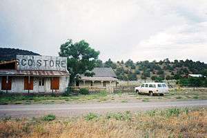 The Frisco Store in Lower Frisco | |
 Lower Frisco | |
| Coordinates: 33°39′05″N 108°47′22″W / 33.65139°N 108.78944°WCoordinates: 33°39′05″N 108°47′22″W / 33.65139°N 108.78944°W | |
| Country | United States |
| State | New Mexico |
| County | Catron |
| Area[1] | |
| • Total | 1.010 sq mi (2.62 km2) |
| • Land | 1.008 sq mi (2.61 km2) |
| • Water | 0.002 sq mi (0.005 km2) |
| Elevation | 5,610 ft (1,710 m) |
| Population (2010)[1] | |
| • Total | 31 |
| • Density | 31/sq mi (12/km2) |
| Time zone | UTC-7 (Mountain (MST)) |
| • Summer (DST) | UTC-6 (MDT) |
| Area code(s) | 575 |
| GNIS feature ID | 2584146[2] |
Lower Frisco is a census-designated place in Catron County, New Mexico, United States. Its population was 31 as of the 2010 census.[1] The community is part of San Francisco Plaza.
Geography
Lower Frisco is located at 33°39′11″N 108°47′15″W / 33.653035°N 108.787558°W. According to the U.S. Census Bureau, the community has an area of 1.010 square miles (2.62 km2); 1.008 square miles (2.61 km2) of its area is land, and 0.002 square miles (0.0052 km2) of it is water.[1]
References
- 1 2 3 4 "2010 Census Gazetteer Files - Places: New Mexico". U.S. Census Bureau. Archived from the original on July 14, 2014. Retrieved August 22, 2014.
- ↑ "Lower Frisco". Geographic Names Information System. United States Geological Survey.
Municipalities and communities of Catron County, New Mexico, United States | ||
|---|---|---|
| Village | 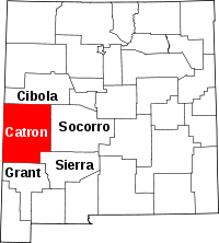 | |
| CDPs | ||
| Other unincorporated communities | ||
| Ghost towns |
| |
| Indian reservation | ||
| Footnotes | ‡This populated place also has portions in an adjacent county or counties | |
This article is issued from
Wikipedia.
The text is licensed under Creative Commons - Attribution - Sharealike.
Additional terms may apply for the media files.