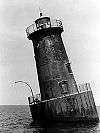
Lower Cedar Point Light
  | |
| Location | in the center of the Potomac River 1.5 mi south of the Harry W. Nice (US 301) Bridge |
|---|---|
| Coordinates | 38°20′24″N 76°59′35″W / 38.340°N 76.993°WCoordinates: 38°20′24″N 76°59′35″W / 38.340°N 76.993°W |
| Year first lit | 1867 |
| Deactivated | 1951 |
| Foundation | screw-pile |
| Construction | cast-iron/wood |
| Tower shape | square house |
| Original lens | fourth-order Fresnel lens |
The Lower Cedar Point Light was a historic lighthouse in the Potomac River near its eponymous point, south of the present U.S. Route 301 bridge. It has been replaced by a skeleton tower.
History
Lightships were stationed at this location beginning in 1825. In 1861, during the Civil War, the lightship at the station was burned by Confederate forces.
A screw-pile lighthouse was constructed on the spot in 1867. This light burned on Christmas Day in 1893 and was rebuilt in 1896. In 1951 the house was removed and a skeleton tower erected on the old foundation.
References
- "Historic Light Station Information and Photography: Maryland". United States Coast Guard Historian's Office.
- Lower Cedar Point Lighthouse, from the Chesapeake Chapter of the United States Lighthouse Society
- de Gast, Robert (1973). The Lighthouses of the Chesapeake. Johns Hopkins University Press. p. 156.
External links
- Rowlett, Russ. "Lighthouses of the United States: Maryland". The Lighthouse Directory. University of North Carolina at Chapel Hill.
This article is issued from
Wikipedia.
The text is licensed under Creative Commons - Attribution - Sharealike.
Additional terms may apply for the media files.