Low Head (Antarctica)
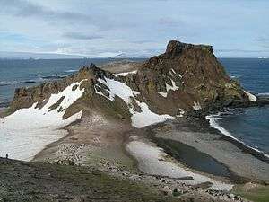
Low Head lies in the background on the right side of this image, nearby Lions Rump lies in the foreground of this image. Two rookeries of chinstrap penguins inhabit this area.
Low Head is a headland 1 nautical mile (2 km) south-southwest of Lions Rump, the west side of the entrance to King George Bay, on King George Island, in the South Shetland Islands, Antarctica. It was charted and given this descriptive name during 1937 by Discovery Investigations personnel on the Discovery II.[1]
References
- ↑ "Low Head". Geographic Names Information System. United States Geological Survey. Retrieved 2013-07-04.
![]()
Coordinates: 62°9′S 58°8′W / 62.150°S 58.133°W
This article is issued from
Wikipedia.
The text is licensed under Creative Commons - Attribution - Sharealike.
Additional terms may apply for the media files.