Loutre Township, Audrain County, Missouri
| Loutre Township | |
|---|---|
| Township | |
 | |
| Coordinates: 39°07′06″N 091°41′48″W / 39.11833°N 91.69667°WCoordinates: 39°07′06″N 091°41′48″W / 39.11833°N 91.69667°W | |
| Country | United States |
| State | Missouri |
| County | Audrain |
| Area | |
| • Total | 56.20 sq mi (145.57 km2) |
| • Land | 55.88 sq mi (144.73 km2) |
| • Water | 0.32 sq mi (0.84 km2) 0.58% |
| Elevation[1] | 814 ft (248 m) |
| Population (2010) | |
| • Total | 824 |
| • Density | 15/sq mi (5.7/km2) |
| FIPS code | 29-44210[2] |
| GNIS feature ID | 0766243 |
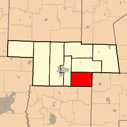
Loutre Township is one of eight townships in Audrain County, Missouri, United States. As of the 2010 census, its population was 824.[3]
Loutre Township was established in 1837, and was named after a creek of the same name within its borders.[4]
Geography
Loutre Township covers an area of 56.2 square miles (145.6 km2) and contains two incorporated settlements: Benton City and Martinsburg. It contains two cemeteries: Martinsburg and Unity.
References
- ↑ "US Board on Geographic Names". United States Geological Survey. 2007-10-25. Retrieved 2008-01-31.
- ↑ "American FactFinder". United States Census Bureau. Retrieved 2008-01-31.
- ↑ "Geographic Identifiers: 2010 Demographic Profile Data (G001): Loutre township, Audrain County, Missouri". U.S. Census Bureau, American Factfinder. Retrieved June 25, 2013.
- ↑ "Audrain County Place Names, 1928-1945 (archived)". The State Historical Society of Missouri. Archived from the original on 24 June 2016. Retrieved 30 August 2016.
External links
Municipalities and communities of Audrain County, Missouri, United States | ||
|---|---|---|
| Cities | 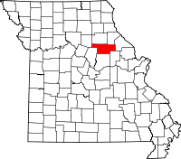 | |
| Villages | ||
| Townships | ||
| Unincorporated communities | ||
| Ghost town | ||
| Footnotes | ‡This populated place also has portions in an adjacent county or counties | |
This article is issued from
Wikipedia.
The text is licensed under Creative Commons - Attribution - Sharealike.
Additional terms may apply for the media files.