Louth County Council
| Louth County Council Comhairle Contae Lú | |
|---|---|
| Type | |
| Type | |
| Leadership | |
|
Liam Reilly, FF | |
| Structure | |
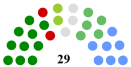
| Seats | 29 |
 | |
Political groups |
|
| Elections | |
Last election | 23 May 2014 |
| Meeting place | |
| County Hall, Dundalk | |
| Website | |
|
louthcoco | |


Louth County Council (Irish: Comhairle Contae Lú) is the authority responsible for local government in County Louth, Ireland. As a county council, it is governed by the Local Government Act 2001. The council is responsible for housing and community, roads and transportation, urban planning and development, amenity and culture, and environment.[1] The council has 29 elected members. Elections are held every five years and are by single transferable vote. The head of the council has the title of Cathaoirleach (Chairperson). The county administration is headed by a Chief Executive, Joan Martin. The county town is Dundalk.
Councillors
For the purpose of elections, the county is divided into four Local Electoral Area's (LEA): Ardee (6 seats), Drogheda (10 seats), Dundalk-Carlingford (6 seats) and Dundalk South (7 seats).[2]
2014 seats summary
| Party | Seats | |
|---|---|---|
| Sinn Féin | 10 | |
| Fine Gael | 6 | |
| Fianna Fáil | 5 | |
| Green Party | 2 | |
| Labour Party | 2 | |
| Independent | 4 | |
Councillors by electoral area
This list reflects the order in which councillors were elected on 23 May 2014.[3]
| Council members from 2014 election | |||
|---|---|---|---|
| Local electoral area | Name | Party | |
| Ardee | Pearse McGeough | Sinn Féin | |
| Colm Markey | Fine Gael | ||
| Tom Cunningham | Sinn Féin | ||
| Liam Reilly | Fianna Fáil | ||
| Dolores Minogue | Fine Gael | ||
| Jim Tenanty | Independent | ||
| Drogheda | Imelda Munster† | Sinn Féin | |
| Paul Bell | Labour Party | ||
| Alan Cassidy† | Sinn Féin | ||
| Tommy Byrne | Fianna Fáil | ||
| Kevin Callan‡ | Fine Gael | ||
| Oliver Tully | Fine Gael | ||
| Frank Godfrey | Independent | ||
| Richie Culhane | Fine Gael | ||
| Pio Smith | Labour Party | ||
| Kenneth Flood | Sinn Féin | ||
| Dundalk-Carlingford | Edel Corrigan | Sinn Féin | |
| Jim Loughran† | Sinn Féin | ||
| Peter Savage | Fianna Fáil | ||
| John McGahon | Fine Gael | ||
| Conor Keelan | Fianna Fáil | ||
| Mark Dearey | Green Party | ||
| Dundalk South | Tomás Sharkey | Sinn Féin | |
| Declan Breathnach† | Fianna Fáil | ||
| Maeve Yore | Independent | ||
| Kevin Meenan† | Sinn Féin | ||
| Jennifer Green† | Sinn Féin | ||
| Marianne Butler | Green Party | ||
| Maria Doyle | Fine Gael | ||
†Replaced during term, see table below for details.
‡Changed party, see table below for details.
Co-options
| Outgoing | Party | Electoral area | Reason | Date | Co-optee | Party | ||
|---|---|---|---|---|---|---|---|---|
| Imelda Munster | Sinn Féin | Drogheda | Elected to Dáil Éireann at the 2016 general election | February 2016 | Joanne Byrne | Sinn Féin | ||
| Declan Breathnach | Fianna Fáil | Dundalk South | Elected to Dáil Éireann at the 2016 general election | February 2016 | Emma Coffey | Fianna Fáil | ||
| Jim Loughran | Sinn Féin | Dundalk-Carlingford | Resignation of Councillor | November 2016 | Antoin Watters | Sinn Féin | ||
| Alan Cassidy | Sinn Féin | Drogheda | Resignation of Councillor | May 2017 | Davin Saurin | Sinn Féin | ||
| Kevin Meenan | Sinn Féin | Dundalk South | Resignation of Councillor | July 2017 | Ruairi O Mhurcu | Sinn Féin | ||
| Jennifer Green | Sinn Féin | Dundalk South | Resignation of Councillor | September 2017 | Anne Campbell | Sinn Féin | ||
Changes in affiliation
| Name | Electoral area | Elected as | New affiliation | Date | ||
|---|---|---|---|---|---|---|
| Kevin Callan | Drogheda | Fine Gael | Independent | November 2014 | ||
Chief executive (county manager)
Each council has a chief executive, previous to 2014 known as city or county manager, who is the manager of the local authority.[4]
| Year | Title | Name | Next Position |
|---|---|---|---|
| 2014–present | Chief executive | Joan Martin[5] | |
| 2013–2014 | County Manager | Philomena Poole | County manager for Dun Laoighaire-Rathdown County Council[6] |
| 2012–2013 | Acting County Manager | Joan Martin | |
| 2007–2012 | County Manager | Conn Murray | City and County Manager for Limerick Council[7] |
Cathaoirleach of Council (Chairman)
Every year, each local authority elects a chair called the Cathaoirleach for a term of one year and a deputy chair called the Leas-Cathaoirleach from among its members. The members elected for each municipal district elect a Cathaoirleach and a Leas-Chathaoirleach for their grouping. The Cathaoirleach chairs the meetings of the local authority or municipal district. Mayor and Deputy Mayor are titles used in municipal districts which were formerly borough councils.[8] Since 1899 there has been 51 Cathaoirleach of Louth County Council.
| Year | Name | Party | |
|---|---|---|---|
| 2017–2018 | Colm Markey | Fine Gael | |
| 2016–2017 | Paul Bell | Labour | |
| 2015–2016 | Peter Savage (7th) | Fianna Fáil | |
| 2014–2015 | Oliver Tully (2nd) | Fine Gael | |
| 2013–2014 | Declan Breathnach (2nd) | Fianna Fáil | |
| 2012–2013 | Finnan McCoy | Fine Gael | |
| 2011–2012 | Oliver Tully (1st) | Fine Gael | |
| 2010–2011 | Peter Savage (6th) | Fianna Fáil | |
| 2009–2010 | Jim D'Arcy | Fine Gael | |
| 2008–2009 | Declan Breathnach (1st) | Fianna Fáil | |
| 2007–2008 | Jimmy Mulroy | Fianna Fáil | |
| 2006–2007 | Jim Lennon | Fine Gael | |
| 2005–2006 | Peter Savage (5th) | Fianna Fáil | |
| 2004–2005 | Terry Brennan | Fine Gael | |
| 2003–2004 | Nicholas McCabe (8th) | Fianna Fáil | |
| 2002–2003 | Jacqui McConville | Fianna Fáil | |
| 2001–2002 | Tommy Reilly | Fianna Fáil | |
| 2000–2001 | Nicholas McCabe (7th) | Fianna Fáil | |
| 1999–2000 | Peter Savage (4th) | Fianna Fáil | |
| 1998–1999 | Miċéal O'Donnell (2nd) | Fianna Fáil | |
| 1997–1998 | Martin Bellew | Independent | |
| 1996–1997 | Thomas Reilly | Fianna Fáil | |
| 1995–1996 | W. Frank Godfrey | Independent | |
| 1994–1995 | Nicholas McCabe (6th) | Fianna Fáil | |
| 1993–1994 | Jim Cousins | Progressive Democrats | |
| 1992–1993 | Peter Savage (3rd) | Fianna Fáil | |
| 1991–1992 | John McConville (2nd) | Fianna Fáil | |
| 1990–1991 | Miċéal O'Donnell (1st) | Fianna Fáil | |
| 1989–1990 | Nicholas McCabe (5th) | Fianna Fáil | |
| 1988–1989 | Peter Savage (2nd) | Fianna Fáil | |
| 1986–1988 | John McConville (1st) | Fianna Fáil | |
| 1985–1986 | Peter Savage (1st) | Fianna Fáil | |
| 1983–1985 | Nicholas McCabe (4th) | Fianna Fáil | |
| 1982–1983 | Patrick Buckley | Fine Gael | |
| 1981–1982 | Nicholas McCabe (3rd) | Fianna Fáil | |
| 1980–1981 | Tommy Elmore | Fine Gael | |
| 1979–1980 | Nicholas McCabe (2nd) | Fianna Fáil | |
| 1976–1979 | Peter J. Moore | Labour | |
| 1975–1976 | Patrick J. O'Hare (2nd) | Fine Gael | |
| 1974–1975 | Nicholas McCabe (1st) | Fianna Fáil | |
| 1973–1974 | Patrick J. O'Hare (1st) | Fine Gael | |
| 1967–1973 | Paddy Donegan | Fine Gael | |
| 1960–1967 | Bernard Rafferty | Fianna Fáil | |
| 1958–1960 | William Woods (2nd) | Independent | |
| 1957–1958 | Laurence Walsh | Fianna Fáil | |
| 1955–1957 | William Woods (1st) | Independent | |
| 1925–1955 | James McGee | Sinn Féin | |
| 1920–1925 | James Murphy | Sinn Féin | |
| 1918–1920 | Patrick McGee | Farmers' Party | |
| 1913–1918 | William Doran | Nationalist Party | |
| 1899–1913 | Peter Hughes | Independent | |
Cathaoirleach party distribution
Breakdown of the 51 times the Cathaoirleach (chair) was held by each political party in Louth, in its 119 year history:
| Party | Times Chair Held | |
|---|---|---|
| Fianna Fáil | 27 | |
| Fine Gael | 12 | |
| Sinn Féin | 2 | |
| Independent | 2 | |
| Labour Party | 2 | |
| Cumann na nGaedheal | 1 | |
| Farmers' Party | 1 | |
| Progressive Democrats | 1 | |
| Nationalist Party | 1 | |
| Green Party | 0 | |
| Unknown | 2 | |
Population by Local Electoral Area
The table below sets out the population of the county broken down by Local Electoral Area, total 2016 population of 128,884.
| LEA | Population (2011) | Population (2016) | Seats | Population per seat |
|---|---|---|---|---|
| Drogheda | 41,925 | 44,052[9] | 10 | 4405 |
| Dundalk South | 28,493 | 30,207[10] | 7 | 4315 |
| Dundalk Carlingford | 24,589 | 25,599[11] | 6 | 4266 |
| Ardee | 27,890 | 29,026[12] | 6 | 4837 |
Population by Municipal District
The table below sets out the population of the county broken down by Municipal District, total 2016 population of 128,884.
 Dundalk Municipal District
 Drogheda Municipal District
 Ardee Municipal District
| District | Population (2011) | Population (2016) | Seats | Population per seat |
|---|---|---|---|---|
| Dundalk | 53,082 | 55,806[13] | 13 | 4292 |
| Drogheda | 41,925 | 44,052[14] | 10 | 4405 |
| Ardee | 27,890 | 29,026[15] | 6 | 4837 |
Population by Electoral Division
The table below sets out the population of the county broken down by Electoral Division.[16]
| Electoral Division | Population (2006) | Population (2011) | Population (2016) |
|---|---|---|---|
| Louth | 111,267 | 122,897 | 128,375 |
| Dundalk (Town + Rural) | 51,758 | 56,761 | 59,557 |
| Dundalk Town | 29,037 | 31,149 | 32,288 |
| 004 Dundalk Urban No. 1 | 2,190 | 2,148 | 2,169 |
| 005 Dundalk Urban No. 2 | 1,211 | 1,169 | 1,140 |
| 006 Dundalk Urban No. 3 | 1,400 | 1,449 | 1,710 |
| 007 Dundalk Urban No. 4 | 6,183 | 6,039 | 5,970 |
| 023 Castletown (Part Urban) | 2,518 | 2,637 | 2,685 |
| 027 Dundalk Rural (Part Urban) | 15,440 | 17,620 | 18,514 |
| 030 Haggardstown (Part Urban) | 95 | 87 | 100 |
| Dundalk rural area | 22,721 | 25,612 | 27,269 |
| 019 Ballymascanlan | 2,016 | 2,213 | 2,206 |
| 020 Barronstown | 647 | 744 | 746 |
| 021 Carlingford | 1,384 | 1,801 | 2,201 |
| 022 Castlering | 935 | 1,012 | 1,034 |
| 023 Castletown (Part Rural) | 1,421 | 1,573 | 1,622 |
| 024 Creggan Upper | 684 | 787 | 852 |
| 025 Darver | 562 | 568 | 678 |
| 026 Drummullagh | 1,120 | 1,257 | 1,350 |
| 027 Dundalk Rural (Part Rural) | 535 | 540 | 686 |
| 028 Faughart | 905 | 991 | 958 |
| 029 Greenore | 979 | 1,169 | 1,201 |
| 030 Haggardstown (Part Rural) | 5,769 | 6,303 | 6,819 |
| 031 Jenkinstown | 948 | 1,173 | 1,277 |
| 032 Killanny | 683 | 799 | 825 |
| 033 Louth | 1,308 | 1,505 | 1,575 |
| 034 Mansfieldstown | 640 | 807 | 855 |
| 035 Rathcor | 1,203 | 1,352 | 1,374 |
| 036 Ravensdale | 982 | 1,018 | 1,010 |
| Drogheda Borough | 28,973 | 28,576 | 29,471 |
| 001 Fair Gate | 9,783 | 9,806 | 10,317 |
| 002 St. Laurence Gate | 3,801 | 4,004 | 4,075 |
| 003 West Gate | 5,899 | 6,042 | 6,284 |
| 041 St. Peter's (Part Urban) | 3,460 | 2,161 | 2,099 |
| 047 St. Mary's (Part Urban) | 6,030 | 6,563 | 6,696 |
| Ardee No. 1 rural area | 17,976 | 20,262 | 20,924 |
| 008 Ardee Rural | 2,626 | 2,875 | 2,952 |
| 009 Ardee Urban | 4,301 | 4,554 | 4,917 |
| 010 Castlebellingham | 1,371 | 1,617 | 1,688 |
| 011 Clonkeen | 545 | 648 | 675 |
| 012 Collon | 1,380 | 1,770 | 1,859 |
| 013 Dromin | 535 | 610 | 629 |
| 014 Dromiskin | 1,935 | 2,187 | 2,226 |
| 015 Drumcar | 1,385 | 1,526 | 1,451 |
| 016 Dunleer | 2,340 | 2,796 | 2,868 |
| 017 Stabannan | 590 | 620 | 619 |
| 018 Tallanstown | 968 | 1,059 | 1,040 |
| Louth rural area | 12,560 | 17,298 | 18,423 |
| 037 Clogher | 2,494 | 3,031 | 3,237 |
| 038 Dysart | 777 | 918 | 925 |
| 039 Monasterboice | 1,164 | 1,342 | 1,365 |
| 040 Mullary | 1,528 | 1,723 | 1,754 |
| 041 St. Peter's (Part Rural) | 4,022 | 6,990 | 7,605 |
| 042 Termonfeckin | 2,575 | 3,294 | 3,537 |
See also
References
- ↑ "Services". Louth County Council. Retrieved 31 March 2011.
- ↑ "2014 Local elections – Louth County Council". ElectionsIreland.org. Retrieved 5 June 2014.
- ↑ "2014 Local elections: Louth County Council". RTÉ News. Archived from the original on 31 May 2014. Retrieved 5 June 2014.
- ↑ Citizensinformation.ie. "Chief Executive of the council". www.citizensinformation.ie. Retrieved 2018-04-17.
- ↑ "Joan first CEO of Louth Council - Independent.ie". Independent.ie. Retrieved 2018-04-17.
- ↑ "Poole set to leave Louth council after six months - Independent.ie". Independent.ie. Retrieved 2018-04-17.
- ↑ "Murray named as new 'super manager' for new Limerick local authority". Retrieved 2018-04-17.
- ↑ Citizensinformation.ie. "Cathaoirleach of the council". www.citizensinformation.ie. Retrieved 2018-04-17.
- ↑ "Census 2016 Sapmap Area: Local Electoral Area Drogheda". census.cso.ie. Retrieved 2018-04-17.
- ↑ "Census 2016 Sapmap Area: Local Electoral Area Dundalk South". census.cso.ie. Retrieved 2018-04-17.
- ↑ "Census 2016 Sapmap Area: Local Electoral Area Dundalk Carlingford". census.cso.ie. Retrieved 2018-04-17.
- ↑ "Census 2016 Sapmap Area: Local Electoral Area Ardee". census.cso.ie. Retrieved 2018-04-17.
- ↑ "Census 2016 Sapmap Area: Municipal District Dundalk". census.cso.ie. Retrieved 2018-04-17.
- ↑ "Census 2016 Sapmap Area: Municipal District Drogheda". census.cso.ie. Retrieved 2018-04-17.
- ↑ "Census 2016 Sapmap Area: Municipal District Ardee". census.cso.ie. Retrieved 2018-04-17.
- ↑ "Census of population by electoral division 2016". CENSUS OF POPULATION 2016 - PRELIMINARY RESULTS / GEOGRAPHIC CHANGES CENSUS OF POPULATION 2016 - PRELIMINARY RESULTS. CSO. Retrieved 17 July 2016.