Las Vegas Boulevard
| Las Vegas Boulevard | |
|---|---|
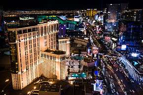 An aerial view of Las Vegas Boulevard as seen from atop the Paris Hotel | |
| Route information | |
| Length | 51.4 mi (82.7 km) |
| Section 1 | |
| South end | Fashion Outlets of Las Vegas, Primm |
| North end | 0.5 mi (0.80 km) north of Primm |
| Section 2 | |
| South end | 2 mi (3.2 km) south of Jean |
| North end |
|
Las Vegas Boulevard is a major, world-famous road in the Las Vegas Valley of Nevada, best known for the Las Vegas Strip portion of the road and its casinos. Formerly carrying U.S. Route 91 (US 91), which had been the main highway between Los Angeles and Salt Lake City, it has been bypassed by Interstate 15, and serves mainly local traffic with some sections designated State Route 604.
Route description
Las Vegas Boulevard runs the length of the Las Vegas metropolitan area in Clark County, Nevada. "The Boulevard", as it is sometimes called by longtime Las Vegas residents, starts at Apex, and continues south to about 2 mi (3.2 km) south of Jean, in the Mojave Desert. The Boulevard shows up again in Primm, Nevada, but is currently not connected to the northern sections. There are tentative plans to connect the existing section at Primm to the northern section at Jean.[1]
Las Vegas Blvd. serves as the Valley's east/west address demarcation boundary line south of the Stratosphere onwards. The road's own north/south street address demarcation boundary is located at its intersection with Fremont Street. Unlike most other cases, where using the more traditional nomenclature of putting the direction before the road name is common practice, The Boulevard is an exception, as it is almost never referred to as "North Las Vegas Boulevard" and "South Las Vegas Boulevard". The road instead is usually referred to as "Las Vegas Boulevard North" (abbreviated LVBN) and "Las Vegas Boulevard South" (stylized LVBS), by both local residents and various media outlets.
At its northern end in Apex, the Boulevard starts in an industrial complex of manufacturing plants and power plants running along the Union Pacific Railroad line. Traveling south, the road meets Nellis Air Force Base on the east side and the Las Vegas Motor Speedway on the west side.
As the road enters the city of North Las Vegas, it passes through some of the older commercial areas in the region. As the road approaches the city of Las Vegas proper, some of what historical Las Vegas was becomes visible, as some of the older casinos appear along with some of the more famous and long-operating strip clubs.
Upon entering the city limits of Las Vegas, the Boulevard showcases the area's past with a number of museums, including the Old Las Vegas Mormon Fort State Historic Park, the Neon Museum, and the Fremont Street Experience and downtown casino sector. On crossing Washington Avenue, the Boulevard is designated as the Downtown Las Vegas Boulevard Scenic Byway by the state. This designation continues south to Sahara Avenue.
Further south is a stretch of road that has many of the older motels, bars and wedding chapels that were among the high points of the old Vegas before the era of the megaresorts.
Las Vegas Strip
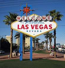
The Boulevard leaves the city of Las Vegas at Sahara Avenue and assumes its unofficial name the Las Vegas Strip for the next 4 miles (6.4 km). This portion of Las Vegas Boulevard begins a few blocks to the north at the Stratosphere (the only major Strip hotel/casino actually sited within the Las Vegas city limits) and runs past Mandalay Bay ending at Russell Road. This is the section of the road most people are familiar with; it is home to casino megaresorts with their world-famous lights, huge video signs and other attractions. It is designated as an All-American Road. Just past the end of "The Strip", the road passes the Welcome to Fabulous Las Vegas sign (located in the median) as it abuts the western edge of the McCarran International Airport property.
The "South Strip" is now used to describe the section of Las Vegas Boulevard between Russell Road and Blue Diamond Road (which was recently relocated to intersect at Windmill Lane). Along this stretch, development thins out except for newer shopping malls, hotels, resorts (such as South Point Casino) and condominiums as the Boulevard continues to travel south, just to the east of Interstate 15.
Public transportation
RTC Transit Route(s) 113 (and the MAX, before February 2016, when it was decommissioned) serves the road from Downtown Las Vegas north to Nellis Air Force Base, The Deuce serves the Road from Downtown Las Vegas south to Mandalay Bay (except from 12:30 am local time to 9:00 am local time where it continues further south to the South Strip Transfer Terminal (SSTT)). South of Circus Circus, alongside it runs the SDX (Strip & Downtown Express) which runs from 9am to 12:30am as a limited stop express line. Route 117 serves the road south from the SSTT past the Las Vegas Premium Outlet South store, the South Point Casino and Silverado Ranch Blvd.
History
Las Vegas Boulevard has had several names, including 5th Street (from Sahara to Owens, within the Las Vegas city limits), Main Street (in North Las Vegas), the Arrowhead Highway, Los Angeles Highway, Salt Lake Highway, US 91 (entire segment), US 93 (from Fremont Street north), US 466 (from Jean to Fremont Street, including the Las Vegas Strip) and State Route 6 (entire segment, unsigned).
South of the city, Las Vegas Boulevard was commonly known as the Los Angeles Highway. Just north of Jean[2] is the place where the last spike on the San Pedro, Los Angeles and Salt Lake Railroad line was driven.
With the construction of I-15, Las Vegas Boulevard went from being the main through road to one that only served as a city street for locals and tourists. Its current name, in effect since 1959, reflects its importance to the Valley rather than past names when it served as a main intra-city road.
On October 16, 2009, the Federal Highway Administration announced the designation of a new National Scenic Byway on the boulevard. The 3.5-mile (5.6 km) section starting at Sahara Avenue and running north to Washington Avenue was designated the City of Las Vegas, Las Vegas Boulevard State Scenic Byway.[3]
See also
References
- ↑ Velotta, Richard. "Southern Nevada motorists getting more than expected from new fuel tax". Las Vegas Review-Journal. Retrieved 1 August 2015.
- ↑ Nevada Historical Marker 195
- ↑ "U.S. Transportation Secretary Ray LaHood Announces America's Byways Designations for 2009" (Press release). Federal Highway Administration. 2009-10-16. Retrieved 2009-10-20.
External links
Route map:

| Preceded by Gardner's Ranch |
Nevada Historical Markers 195 |
Succeeded by Carson City Mint |