Lopo Homem
Lopo Homem (16th century) was a Portuguese cartographer and cosmographer.
Biography
In 1517, King Manuel I of Portugal handed Lopo Homem a charter entitling him the privilege of certifying and amending all compass needles in vessels. This charter was revalidated in 1524 by King John III of Portugal. Anytime another person performed these tasks, they should have paid to the cartographer twenty cruzados. Two years later Lopo Homem participated in the making of the atlas known as "Lopo Homem-Reineis Atlas" or "Miller Atlas" with cartographer Pedro Reinel and his son, Jorge Reinel. They were considered the best cartographers of their time, with Emperor Charles V wanting them to work for him.
In 1524, he participated on the Portuguese side in the Conferences of Badajoz-Elvas, established by the Crowns of Portugal and Spain following the so-called "Moluccas issue". A letter written by Lopo Homem alluding to the board quarrels over the claims of the two kings on exploration rights remains in Torre do Tombo. In 1531, Lopo Homem was awarded a pension of 20,000 reais for life, increased to 5,000 in 1532. He was the father of Diogo Homem, also a cartographer.
Works
His earliest known work is a world map, discovered in London in 1930. In Florence there is another world map dated 1554, and Lisbon's National Library has also a navigation chart (which before 1910 was in the Palácio das Necessidades, having belonged to Charles I of Portugal). Scholar Armando Cortesão's "Cartography and Portuguese cartographers in the fifteenth and sixteenth" includes an extensive section devoted to Lopo Homem.
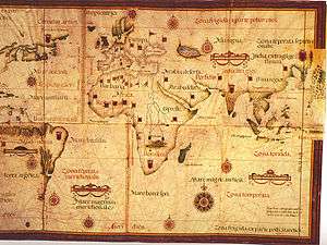
- 1519 world map - surrounded by the four winds in the extremities, with relatively scarce naming in Latin: in Africa are identified only the regions of Libya, Ethiopia and Guinea, and Americas is identified as "Mundus Novus Brazil", linked to the Asian continent by an imaginary continent identified generically as "Mundus Novus".
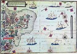
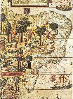
- 1519 - Terra Brasilis - part of the "Miller Atlas", attributed to Lopo Homem - currently in the French National Library in Paris. This is a chart handwritten on parchment, with detailed nomenclature in Latin (146 names), showing the Brazilian coast from Maranhão to the Rio da Prata. The rich Miniatures show Native Americans, some involved in the business activities of Brazilwood export. A coat of arms at the north (Guyana) and the other to the south (Argentina), indicate the areas of the Portuguese and Spanish crowns.
- 1554 - Map currently in Florence;
- Maritime Chart - (currently in the National Library of Portugal)
See also
Bibliography
- CORTESÃO, Armando; MOTA, Avelino Teixeira da. Portugaliae monumenta cartographica (v. IV). Lisboa: Imprensa Nacional-Casa da Moeda, 1987. Reprodução fac-similar da edição de 1960.
- DIAS, Maria Helena; BOTELHO, Henrique Ferreira (coord.). Quatro séculos de imagens da Cartografia portuguesa = Four centuries of images from Portuguese Cartography (2ª ed.). Lisboa: Comissão Nacional de Geografia [etc.], 1999. ISBN 972-765-787-7.
- VITERBO, Sousa. Trabalhos Náuticos dos Portugueses, Séculos XVI e XVII. Lisboa: INCM, 1988.
| Authority control |
|---|