Lone Pine Peak
| Lone Pine Peak | |
|---|---|
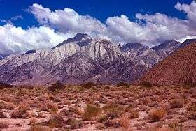 Lone Pine Peak from the Owens Valley | |
| Highest point | |
| Elevation | 12,949 ft (3,947 m) NAVD 88[1] |
| Prominence | 424 ft (129 m) [1] |
| Parent peak | Rosco Peak[2] |
| Listing | Sierra Peaks Section[3] |
| Coordinates | 36°33′42″N 118°13′30″W / 36.5616014°N 118.2250896°WCoordinates: 36°33′42″N 118°13′30″W / 36.5616014°N 118.2250896°W [4] |
| Geography | |
 Lone Pine Peak  Lone Pine Peak | |
| Location | Inyo County, California, U.S. |
| Parent range | Sierra Nevada |
| Topo map | USGS Mount Langley |
| Climbing | |
| First ascent | 1925 by Norman Clyde[5] |
| Easiest route | Scramble, class 2[3] |
Lone Pine Peak is located on the east side of the Sierra Nevada range just west of the town of Lone Pine, California[6] in Inyo County, in eastern California in the southwestern United States.[4] The summit marks the eastern boundary of the John Muir Wilderness in the Inyo National Forest. Lone Pine Peak is the mountain in the photo for the default desktop of macOS Sierra.[7]
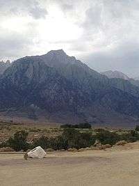
Lone Pine Peak shot from the East
References
- 1 2 "Lone Pine Peak, California". Peakbagger.com. Retrieved 2014-01-16.
- ↑ "Key Col for Lone Pine Peak". Peakbagger.com. Retrieved 2016-03-23.
- 1 2 "Sierra Peaks Section List" (PDF). Angeles Chapter, Sierra Club. Retrieved 2014-02-01.
- 1 2 "Lone Pine Peak". Geographic Names Information System. United States Geological Survey. Retrieved 2014-01-17.
- ↑ Roper, Steve (1976). The Climber's Guide to the High Sierra. San Francisco: Sierra Club Books. p. 370. ISBN 9780871561473.
- ↑ "Lone Pine Peak". SummitPost.org. Retrieved 2014-01-16.
- ↑ "MacOS Sierra features Mt. Whitney | General Discussion | WhitneyZone Message Board". Retrieved 7 January 2017.
This article is issued from
Wikipedia.
The text is licensed under Creative Commons - Attribution - Sharealike.
Additional terms may apply for the media files.