Locust Gap, Pennsylvania
| Locust Gap | |
|---|---|
| Unincorporated community | |
 Locust Gap Location within the state of Pennsylvania | |
| Coordinates: 40°46′18″N 76°26′30″W / 40.77167°N 76.44167°WCoordinates: 40°46′18″N 76°26′30″W / 40.77167°N 76.44167°W | |
| Country | United States |
| State | Pennsylvania |
| County | Northumberland |
| Area | |
| • Total | 9.18 sq mi (23.8 km2) |
| • Land | 9.18 sq mi (23.8 km2) |
| • Water | 0.00 sq mi (0.00 km2) |
| Elevation | 1,191 ft (363 m) |
| Population (2000) | |
| • Total | 388 |
| • Density | 42/sq mi (16/km2) |
| Time zone | UTC-5 (Eastern (EST)) |
| • Summer (DST) | UTC-4 (EDT) |
| Area code(s) | 570 |
| GNIS feature ID | 1179772[1] |
Locust Gap is an unincorporated community in Northumberland County, Pennsylvania, United States. It is about two miles southwest of Mount Carmel.
Geography
Locust Gap is located at an elevation 1191 feet.
Major roads
References
Municipalities and communities of Northumberland County, Pennsylvania, United States | ||
|---|---|---|
| Cities | 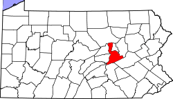 | |
| Boroughs | ||
| Townships | ||
| CDPs | ||
| Unincorporated communities | ||
This article is issued from
Wikipedia.
The text is licensed under Creative Commons - Attribution - Sharealike.
Additional terms may apply for the media files.