Lochluichart railway station
| Lochluichart | |
|---|---|
| Scottish Gaelic: Loch Laoicheart[1] | |
 | |
| Location | |
| Place | Lochluichart |
| Local authority | Highland |
| Coordinates | 57°37′18″N 4°48′33″W / 57.6218°N 4.8091°WCoordinates: 57°37′18″N 4°48′33″W / 57.6218°N 4.8091°W |
| Grid reference | NH323625 |
| Operations | |
| Station code | LCC |
| Managed by | Abellio ScotRail |
| Number of platforms | 1 |
|
Live arrivals/departures, station information and onward connections from National Rail Enquiries | |
| Annual rail passenger usage* | |
| 2012/13 |
|
| 2013/14 |
|
| 2014/15 |
|
| 2015/16 |
|
| 2016/17 |
|
| History | |
| Original company | Dingwall and Skye Railway |
| Pre-grouping | Highland Railway |
| Post-grouping | LMS |
| 1 August 1871 | Opened as Lochluichart High[2] |
| 3 May 1954 | Resited and renamed as 'Lochluichart[2] |
| National Rail – UK railway stations | |
| * Annual estimated passenger usage based on sales of tickets in stated financial year(s) which end or originate at Lochluichart from Office of Rail and Road statistics. Methodology may vary year on year. | |
|
| |
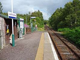
Lochluichart railway station is a railway station on the Kyle of Lochalsh Line, serving the village of Lochluichart in the north of Scotland. Lochluichart is located at the north edge of Loch Luichart.
The station is 17 miles 20 chains (27.8 km) from Dingwall, and has a single platform which is long enough for a three-coach train.[3]
History
The station was opened as Lochluichart High[2] by the Dingwall and Skye Railway on 1 August 1871 as a private station for Lady Ashburnton on the Lochluichart Estate. Became a public station by 1887.[4]
In 1949 Lochluichart was planned to be relocated to allow the flooding of the area by the Glascarnoch-Luichart-Torr Achilty hydroelectric scheme.[5] On 3 May 1954 a new station was opened as Lochluichart[2] as a result of a hydro electric scheme raising the level of Loch Luichart, constructed of red sandstone. The deviation required about 2-mile (3.2 km) on stone-pitched embankments and in rock cuttings, a 100-foot (30 m) bridge over the River Conon and a 36-foot (11 m) bridge.[6]
Services
Four trains each way call (on request) on weekdays/Saturdays and one each way all year on Sundays, plus a second from May to late September only.[7]
| Preceding station | Following station | |||
|---|---|---|---|---|
| Garve | Abellio ScotRail Kyle of Lochalsh Line |
Achanalt | ||
| Historical railways | ||||
| Garve | Highland Railway Dingwall and Skye Railway |
Achanalt | ||
References
Notes
- ↑ Brailsford 2017, Gaelic/English Station Index.
- 1 2 3 4 Butt (1995), page 147
- ↑ Brailsford 2017, map 22F.
- ↑ Private and Untimetabled Railway Stations by G.Croughton page 96
- ↑ "A Station To Be Moved". Dundee Courier. Scotland. 6 May 1949. Retrieved 15 November 2017 – via British Newspaper Archive. (Subscription required (help)).
- ↑ Cooke, B.W.C., ed. (June 1954). "Re-Siting of Lochluichart Station". The Railway Magazine. Vol. 100 no. 638. Westminster: Tothill Press. p. 432.
- ↑ GB eNRT May 2016 Edition, Table 239
Sources
- Brailsford, Martyn, ed. (December 2017) [1987]. Railway Track Diagrams 1: Scotland & Isle of Man (6th ed.). Frome: Trackmaps. ISBN 978-0-9549866-9-8.
- Butt, R. V. J. (1995). The Directory of Railway Stations: details every public and private passenger station, halt, platform and stopping place, past and present (1st ed.). Sparkford: Patrick Stephens Ltd. ISBN 978-1-85260-508-7. OCLC 60251199.
- Jowett, Alan (2000). Jowett's Nationalised Railway Atlas (1st ed.). Penryn, Cornwall: Atlantic Transport Publishers. ISBN 978-0-906899-99-1. OCLC 228266687.
- Jowett, Alan (March 1989). Jowett's Railway Atlas of Great Britain and Ireland: From Pre-Grouping to the Present Day (1st ed.). Sparkford: Patrick Stephens Ltd. ISBN 978-1-85260-086-0. OCLC 22311137.
External links
- "Lochluichart station on navigable O.S. map".
- "Dingwall and Skye Railway". RailScot. Retrieved 2 February 2011.
| Wikimedia Commons has media related to Lochluichart railway station. |