Loch of Kirbister
| Loch of Kirbister | |
|---|---|
| Kirbister loch, Loch of Orphir[1] | |
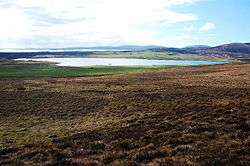 Looking roughly SW over moorland down to the loch. | |
| Location | Mainland Orkney, Scotland |
| Coordinates | 58°57′08″N 3°5′36″W / 58.95222°N 3.09333°WCoordinates: 58°57′08″N 3°5′36″W / 58.95222°N 3.09333°W |
| Type | freshwater loch |
| Primary inflows | several burns [1] |
| Primary outflows | Mill burn at south end in to Waulkmill Bay[1] |
| Catchment area | 8 sq mi (21 km2)[1] |
| Basin countries | Scotland |
| Max. length | 1.25 mi (2.01 km)[1] |
| Max. width | 0.5 mi (0.80 km)[1] |
| Surface area | 227 acres (0.92 km2)[1] |
| Average depth | 4 ft (1.2 m)[1] |
| Max. depth | 6 ft (1.8 m)[1] |
| Water volume | 41,000,000 cu ft (1,200,000 m3)[1] |
| Surface elevation | 52 ft (16 m)[1] |
| Islands | Holm of Groundwater[2] |
The Loch of Kirbister is a small, shallow, somewhat triangular shaped loch on Mainland Orkney, Scotland, in the parish of Orphir. It lies 5 mi (8.0 km) south west of Kirkwall on cultivated land between two hills. There is a small (37 m (121 ft) by 19 m (62 ft)) turf covered islet known as the Groundwater of Holm just off the eastern shore of the loch. It shows traces in stone of an oval structure and small projecting pier.[2] The loch is popular for trout fishing and the Orkney Trout Fishing Association has a hatchery at the Kirbister pumphouse [3] on the loch edge.
Mill Burn, the southerly outflow from the loch, was used to power the 18th century Kirbister Mill.[4]
The loch was surveyed[1] in 1903 by T.N. Johnston and R.C. Marshall and later charted [5] as part of Sir John Murray's The Bathymetrical Survey of Fresh-Water Lochs of Scotland 1897-1909.[6]
References
- 1 2 3 4 5 6 7 8 9 10 11 12 "Bathymetrical Survey of the Fresh-Water Lochs of Scotland, 1897-1909, Lochs of Orkney". National Library of Scotland. Retrieved 2013-08-11.
- 1 2 "Loch of Kirbister - Groundwater of Holm". Canmore. RCAHMS. Retrieved 2013-08-11.
- ↑ "New trout hatchery at Kirbister". Orkney Trout Fishing Association. OTFA. Retrieved 2013-08-11.
- ↑ "Kirbister Mill". Canmore. RCAHMS. Retrieved 2013-08-11.
- ↑ "Muckle & Peerie Waters; Loch of Isbister; Loch of Sabiston; Loch of Kirbister; Loch of Tankerness (Vol. 6, Plates 91 & 92) - Bathymetrical Survey, 1897-1909 - National Library of Scotland". National Library of Scotland. Retrieved 2013-08-11.
- ↑ Murray, John; Pullar, Laurence (1910). Bathymetrical Survey of Fresh-Water Lochs of Scotland during the years 1897 to 1909: report on scientific results. Edinburgh. Retrieved 24 July 2013.