Loch a' Ghobhainn
| Loch a' Ghobhainn | |
|---|---|
 | |
| Location | Wester Ross, Highlands Scotland |
| Coordinates | 57°37′50″N 5°35′50″W / 57.6305°N 5.5971°WCoordinates: 57°37′50″N 5°35′50″W / 57.6305°N 5.5971°W[1] |
| Type | freshwater loch |
| Basin countries | Scotland |
| Max. length | 0.75 mi (1.21 km)[2] |
| Max. width | 0.3 mi (0.48 km)[2] |
| Surface area | 108.7 ha (269 acres)[1] |
| Average depth | 12.5 ft (3.8 m)[2] |
| Max. depth | 28 ft (8.5 m)[2] |
| Water volume | 54,000,000 cu ft (1,500,000 m3)[2] |
| Shore length1 | 3.1 km (1.9 mi)[1] |
| Surface elevation | 308 m (1,010 ft)[1] |
| Islands | 2[1] |
| 1 Shore length is not a well-defined measure. | |
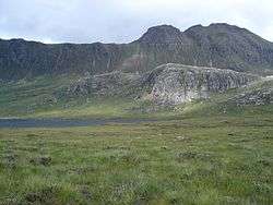
Loch a' Ghobhainn is an upland freshwater loch lying inland and south west of the village of Shieldaig in the Scottish Highlands. The loch has an irregular, somewhat elliptical shape with a perimeter of 3.1 km (1.9 mi). It is approximately 0.75 mi (1.21 km) long, has an average depth of 12.5 ft (3.8 m) and is 28 ft (8.5 m) at its deepest. The loch was surveyed[2] on 8 August 1902 by T.N. Johnston and John Hewitt and later charted[3] as part of Sir John Murray's Bathymetrical Survey of Fresh-Water Lochs of Scotland 1897-1909.
References
- 1 2 3 4 5 "Loch a' Ghobhainn". British lakes. British Lakes. Retrieved 12 June 2016.
- 1 2 3 4 5 6 "Bathymetrical Survey of the Fresh-Water Lochs of Scotland, 1897-1909, Lochs of the Gairloch Basin". National Library of Scotland. Retrieved 12 June 2016.
- ↑ "Lochs a' Bhealaich, a' Ghobhainn & na h-Oidhche (Vol. 5, Plate 19), Bathymetrical Survey, 1897-1909". National Library of Scotland. Retrieved 12 June 2016.
This article is issued from
Wikipedia.
The text is licensed under Creative Commons - Attribution - Sharealike.
Additional terms may apply for the media files.