Loch Veyatie
| Loch Veyatie | |
|---|---|
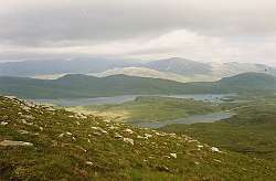 View towards Loch Veyatie With the Cam Loch beyond and Ben More Assynt under cloud in the distance. | |
| Location | Scotland |
| Coordinates | 58°4′30″N 5°5′20″W / 58.07500°N 5.08889°WCoordinates: 58°4′30″N 5°5′20″W / 58.07500°N 5.08889°W |
| Primary outflows | Uidh Fheàrna |
| Basin countries | United Kingdom |
| Max. depth | 30 m (98 ft) |
| Settlements | Elphin |
Loch Veyatie (Gaelic: Loch Mheathadaidh) is a large body of water in north-west Scotland.[1][2] It stretches for 6 km north-westwards from the settlement of Elphin, and lies between Suilven and Cùl Mòr. It reaches depths of around 30 m.
Parish Boundary
The boundary between Ross-shire and Sutherland (and therefore between the parishes of Lochbroom and Assynt) runs the length of the loch.
Angling
Well known for its trout (including ferox) and charr, it is a popular destination for anglers. Run-off from a salmon hatchery at the eastern end of the loch attracts large fish, including, unusually, charr, into its main feeder river, the Abhainn Mhòr. The resovoir Cam Loch is directly located 1km to the northeast, and follows the same orientation.
Geography
Loch Veyatie is drained at its western end by Uidh Fheàrna, a channel of slow-moving water leading into Fionn Loch, which is itself drained by the River Kirkaig leading to the notable 20m Falls of Kirkaig before entering Loch Kirkaig.[3]
Frigate
The Loch-class frigate HMS Loch Veyatie was named after the loch.
Gallery
- Images of Veyatie and surrounding areas
 Bay below Creagan Mòr, Loch Veyatie. This sheltered bay was most welcome by a group of anglers on a rather windy day. At the inner end of the bay is the small beach
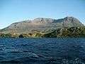 Cul Mor from a boat on Loch Veyatie
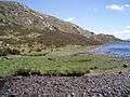 Far eastern end of Uidh Fhearna looking eastback down the side of Loch Veyatie The 'shore' of the loch here was fairly flat before narrowing down towards Uidh Fhearna
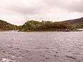 Unnamed micro island on Loch Veyatie
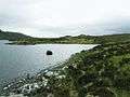
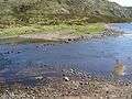 Loch shallows
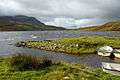 View of Loch Veyatie with Cul Mòr in the distance.Note the man made dock.
 Loch Veyatie, north shore. Less appealing than the beach a few hundred metres to the east.
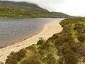 Sandy beach, Loch Veyatie Under different skies, the beach might have been more tempting but with strong winds and rain showers, this is as far as beach life went.
 Sandy beach, Loch Veyatie Sandstone being recycled back to its former state here!
References
- ↑ "Bathymetrical Survey of the Fresh-Water Lochs of Scotland, 1897-1909". Maps. The national library of Scotland. Retrieved 25 November 2017.
- ↑ Lochs of the Kirkaig Basin (pdf). National Library of Scotland Maps: Bathymetrical Survey of the Fresh-Water Lochs of Scotland. 1897–1909. p. 163. Retrieved 25 November 2017.
- ↑ Microsoft; Nokia (25 November 2017). "Loch Veyatie" (Map). Bing Maps. Microsoft. Retrieved 25 November 2017.