Loch Màma
| Loch Màma | |
|---|---|
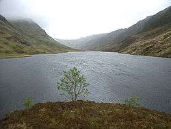 Loch Màma from the far western shore | |
| Location | Morar, Lochaber, Scotland |
| Coordinates | 56°55′58″N 5°40′18″W / 56.93278°N 5.67167°W[1] |
| Type | freshwater loch[2] |
| Primary inflows | Loch na Creige Duibhe[2] |
| Primary outflows | Gleann Màma [3] |
| Basin countries | Scotland |
| Max. length | 0.33 mi (0.53 km)[2] |
| Max. width | 0.125 mi (0.201 km)[2] |
| Surface area | 17 acres (0.069 km2)[2] |
| Average depth | 14.25 ft (4.34 m)[2] |
| Max. depth | 44 ft (13 m)[2] |
| Water volume | 11,000,000 cu ft (310,000 m3)[2] |
| Surface elevation | 359 ft (109 m)[2] |
Loch Màma is a small freshwater loch in South Morar, Lochaber, in the north west of Scotland. It forms a simple basin and is orientated east to west. It is thought that the adjoining loch Loch na Creige Duibhe and Loch Màma were at one time a single loch. Debris brought down by the Allt Dearg stream has likely caused the lochs to be separated into two bodies of water. The loch is the source of the river Allt a' Mhama.[1]
The loch was surveyed on 11 July 1902[2] by James Parsons and T.R.H. Garrett and later charted[4] as part of the Sir John Murray and Laurence Pullar's Bathymetrical Survey of Fresh-Water Lochs of Scotland 1897-1909.
References
- 1 2 "Mama, Loch". Gazetteer for Scotland. Retrieved 15 November 2014.
- 1 2 3 4 5 6 7 8 9 10 "Bathymetrical Survey of the Fresh-Water Lochs of Scotland, 1897-1909, Lochs of the nan Uamh Basin". National Library of Scotland. Retrieved 15 November 2014.
- ↑ "Sheet 46 - Ardnamurchan & Loch Shiel". National Library of Scotland. Retrieved 15 November 2014.
- ↑ "Lochs Mama and na Creige Duibhe; Loch Dubh (Vol. 4, Plate 56 - Mylar sheet 21)". National Library of Scotland. Retrieved 15 November 2014.
See also
This article is issued from
Wikipedia.
The text is licensed under Creative Commons - Attribution - Sharealike.
Additional terms may apply for the media files.