Llyn y Fan Fawr
| Llyn y Fan Fawr | |
|---|---|
 | |
| Location | Powys, Wales |
| Coordinates | 51°52′52″N 3°42′0″W / 51.88111°N 3.70000°WCoordinates: 51°52′52″N 3°42′0″W / 51.88111°N 3.70000°W |
| Type | natural |
| Primary outflows | River Tawe |
| Basin countries | United Kingdom |
| Surface elevation | 605 m (1815 feet) |
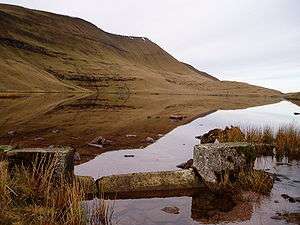
Llyn y Fan Fawr (Welsh: 'lake of the big peak') is a natural lake in the county of Powys, Wales. It lies at the foot of Fan Brycheiniog,[1] the highest peak of the Black Mountain (WelshY Mynydd Du) range within the Brecon Beacons National Park. Created as a result of glacial action,[2] it is one of the largest glacial lakes in southern Wales.[3] The lake is roughly rectangular in shape with its long axis oriented roughly north-south.
The surface of Llyn y Fan Fawr lies at about 1815 feet or 605m above sea level.[4][5] Its primary outflow is to the River Tawe.[6] Much of the land around the lake is peaty and thus wet underfoot.
References
- ↑ Andrew Davies; David Whittaker (9 September 2010). Walking on the Brecon Beacons. Cicerone Press Limited. pp. 191–. ISBN 978-1-84965-346-6.
- ↑ Geological Survey of Great Britain (1932). Memoirs. England and Wales: Explanation of Sheet. H.M. Stationery Office.
- ↑ Derek Ratcliffe (26 January 2012). A Nature Conservation Review: Volume 1: The Selection of Biological Sites of National Importance to Nature Conservation in Britain. Cambridge University Press. pp. 236–. ISBN 978-0-521-20329-6.
- ↑ Hans Luther; Julian Rzóska (1971). Project Aqua: A Source Book of Inland Waters Proposed for Conservation. International Biological Programme. ISBN 978-0-632-08730-3.
- ↑ Ordnance Survey Explorer map OL12 'Brecon Beacons National Park: western area'
- ↑ Bye-gones: Relating to Wales and the Border Counties. Printed at the Caxton workd. 1894. pp. 504–.
External links
This article is issued from
Wikipedia.
The text is licensed under Creative Commons - Attribution - Sharealike.
Additional terms may apply for the media files.