Livarden
| Livarden | |
|---|---|
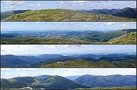 Views from Livarden from the north, west, south, and east | |
| Highest point | |
| Elevation | 683 m (2,241 ft) |
| Prominence | 210 m (690 ft) |
| Coordinates | 60°20′35″N 05°28′11″E / 60.34306°N 5.46972°ECoordinates: 60°20′35″N 05°28′11″E / 60.34306°N 5.46972°E |
| Geography | |
 Livarden Location in Hordaland | |
| Location | Hordaland, Norway |
Livarden is a mountain in the city of Bergen in Hordaland county, Norway. It is located south-east of the Ulriken mountain massif, on the border of the boroughs of Fana and Arna, just south of the village of Espeland. The summit is situated at 683 metres (2,241 ft) above sea level, with a prime factor of 210 metres (690 ft).[1]
References
- ↑ "Livarden" (in Norwegian). Bergen byarkiv. Retrieved 2014-09-23.
This article is issued from
Wikipedia.
The text is licensed under Creative Commons - Attribution - Sharealike.
Additional terms may apply for the media files.