Little Sucker River
| Little Sucker River | |
|---|---|
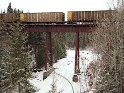 A railway bridge over the frozen Little Sucker River | |
| Country | United States |
| Physical characteristics | |
| Main source | Minnesota |
| River mouth | Lake Superior |
| Length | 1.6 miles (2.6 km) |
The Little Sucker River is a 1.6-mile-long (2.6 km)[1] stream in St. Louis County, Minnesota, flowing directly into Lake Superior.
See also
Coordinates: 46°55′38″N 91°50′05″W / 46.9271581°N 91.8346253°W[2]
References
- ↑ U.S. Geological Survey. National Hydrography Dataset high-resolution flowline data. The National Map Archived 2012-04-05 at WebCite, accessed May 7, 2012
- ↑ U.S. Geological Survey Geographic Names Information System: Little Sucker River
- Minnesota Watersheds
- USGS Hydrologic Unit Map - State of Minnesota (1974)
This article is issued from
Wikipedia.
The text is licensed under Creative Commons - Attribution - Sharealike.
Additional terms may apply for the media files.