Little River (Passamaquoddy Bay)
| Little River | |
|---|---|
 | |
| Country | United States |
| Physical characteristics | |
| Main source | Maine |
| River mouth |
Passamaquoddy Bay sea level 44°58′15″N 67°03′27″W / 44.9709°N 67.0574°WCoordinates: 44°58′15″N 67°03′27″W / 44.9709°N 67.0574°W |
| Length | about 2 miles (3 km) |
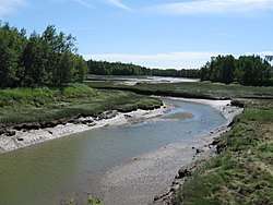
The Little River is a short, mostly-tidal river in Perry, Maine. From Boyden Stream Reservoir (44°58′20″N 67°05′23″W / 44.9721°N 67.0896°W) it runs about 2 miles (3 km)[1] east to Passamaquoddy Bay.
See also
References
- ↑ U.S. Geological Survey. National Hydrography Dataset high-resolution flowline data. The National Map Archived 2012-04-05 at WebCite, accessed June 22, 2011
- "Little River". Geographic Names Information System. United States Geological Survey. 30 September 1980. Retrieved 2010-03-15.
- Maine Streamflow Data from the USGS
- Maine Watershed Data From Environmental Protection Agency
This article is issued from
Wikipedia.
The text is licensed under Creative Commons - Attribution - Sharealike.
Additional terms may apply for the media files.