List of volcanoes in Spain
Canary Islands

| Name | Elevation | Location | Last eruption | |
| meters | feet | Coordinates | ||
| Fuerteventura | 812 | 1735 | 28°21′29″N 14°01′12″W / 28.358°N 14.02°W | 4000-5000 BC |
| Gran Canaria | 1949 | 6398 | 28°00′N 15°35′W / 28.00°N 15.58°W | 20 BC |
| Hierro | 1501 | 4920 | 27°44′N 18°02′W / 27.73°N 18.03°W | 2011 |
| La Palma | 2426 | 6394 | 28°35′N 17°50′W / 28.58°N 17.83°W | 1971 |
| Lanzarote | 670 | 2060 | 29°02′N 13°38′W / 29.03°N 13.63°W | 1824 |
| Tenerife | 3718 | 12,188 | 28°16′N 16°38′W / 28.27°N 16.64°W | 1909 |
Lanzarote
- Caldera Blanca
- Guanapay
- Massif of Marissa
- Massif of Los Ajaches
- Montaña de El Golfo
- Montaña del Fuego
- Montaña Negra
- Pico Colorado
- Timanfaya Volcanic Field
- Volcan of La Corona
Fuerteventura
- Lobos's Island volcanic field
- Massif of Betancuria
- Massif of Haler
- Montaña de La Arena
- Montaña de Tindaya
- Vulcan of Jacomar
Gran Canaria
- Caldera of Bandama
- Caldera of Tejeda
- La Isleta volcanic field
- Massif of Güigüi
- Massif of Tamadaba
- Haler de Arinaga
- Montaña de Arucas
- Montaña de Gáldar
- Montañón Negro
- Stratovolcano of Roque Nublo
Tenerife
- Caldera of Las Canadas
- Massif of Anaga
- Massif of Teno
- Montana de Las Arenas
- Pedro Gil ridge
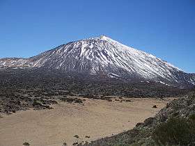
- Teide
- Teno ridge
- Vulcan of Arafo
- Vulcan of Chahorra
- Vulcan Chinyero
- Vulcan of Fasnia
La Gomera
La Palma
- Cumbre Vieja ridge
- Northern ancient massif
- Vulcan of Fuencaliente
- Vulcan of El Charco
- Vulcan of San Juan
- Vulcan of San Antonio
- Vulcan of San Martin
- Vulcan of Tacande
- Vulcan of Tajuya
- Vulcan of Teneguía
El Hierro
- Vulcan of Lomo Negro
Mainland Spain
There are several volcanic areas in mainland Spain, such as:[1]
- Cabo de Gata, Almería
- Campo de Calatrava, Ciudad Real
- Cofrentes, Valencia
- Columbretes Islands, Castellón
- Garrotxa Volcanic Zone, Girona
- Campos de Cartagena, Cartagena (Upper Miocene)
- Isla Grosa, in the Mediterranean east of La Manga del Mar Menor
- Cerro del Calnegre and Monteblanco, on La Manga del Mar Menor
- Isla Mayor o del Barón, Isla Perdiguera, Isla del Ciervo, Isla Rondella o Redonda and Isla del Sujeto in the Mar Menor
- El Carmolí, on the landward coast of the Mar Menor.
- Cabezo Beaza, Cabezo de la Fraila and Cabezo Ventura, on the eastern edge of Cartagena
- Volcán Aljorra, northwest of Cartagena
- Cabezo Negro de Tallante, Pico Cebolla and Los Pérez, west-northwest of Cartagena

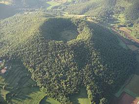
Aerial view of the Croscat volcano.
Aerial view of the Santa Margarida Volcano.
Montolivet Volcano in Olot.
.jpg)
Garrinada Volcano in Olot.
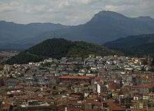
Garrotxa Volcanic Zone
There are 40 volcanoes at the comarca of the Garrotxa, 38 of which are part of the Garrotxa Volcanic Zone Natural Park.[2]
- Volcà de la Canya
- Volcà d’Aiguanegra
- Volcà de Repàs
- Volcà de Repassot
- Volcà del Cairat
- Volcà de Claperols
- Volcà del Puig de l’Ós
- Volcà del Puig de l’Estany
- Volcà del Puig de Bellaire
- Volcà de Gengí
- Volcà del Bac de les Tries
- Volcà de les Bisaroques
- Volcà de la Garrinada
- Volcà del Montsacopa
- Volcà de Montolivet
- Volcà de Can Barraca
- Volcà del Puig Astrol
- Volcà de Pujalós
- Volcà del Puig de la Garsa
- Volcà del Croscat
- Volcà de Cabrioler
- Volcà del Puig Jordà
- Volcà del Puig de la Costa
- Volcà del Puig de Martinyà
- Volcà del Puig de Mar
- Volcà de Santa Margarida
- Volcà de Comadega
- Volcà del Puig Subià
- Volcà de Rocanegra
- Volcà de Simon
- Volcà del Pla sa Ribera
- Volcà de Sant Jordi
- Volcà del Racó
- Volcà de Fontpobra
- Volcà de la Tuta de Colltort
- Volcà de Can Tià
- Volcà de Sant Marc[lower-roman 1]
- Volcà del Puig Roig[lower-roman 1]
- Volcà del Traiter
- Volcà de les Medes
- 1 2 Located outside the Garrotxa Volcanic Zone Natural Park.
Additionally, there are at least seven other volcanoes located in the Province of Girona:[2]
- Volcà de la Crosa de Sant Dalmai
- Volcà del Puig d’Adri
- El Rocàs
- Volcà del Clot de l’Omera
- Volcà del Puig de la Banya del Boc
- Volcà de Granollers de Rocacorba
- Puig Montner
Major eruptions
| Year1 | Name/Volcano | Island | Eruption/Cessation date | Duration (days) |
| 1430/1440 | Tacande o Montaña Quemada | La Palma | ? | ? |
| 1492 | Eruption of Colón | Tenerife | ? | ? |
| 1585 | Tehuya | La Palma | 19 May/10 Aug | 84 |
| 1646 | V. Martín o de Tigalate | La Palma | 2 Oct/ 21 Dec | 82 |
| 1667/1678 | V. de San Antonio | La Palma | 17 Nov/21 Jan | 66 |
| 1704/1705 | V. de Sietefuentes | Tenerife | 31 Dec/4 or 5 Jan | 5 |
| 1704/1705 | V. de Fasnia | Tenerife | 5 Jan/ 16 Jan | 12 |
| 1704/1705 | V. de Arafo | Tenerife | 2 Feb/27 Mar | 54 |
| 1706 | E. de Garachico / V. de Arenas Negras | Tenerife | 5 May/13 Jun | 40 |
| 1712 | E. del Charco | La Palma | 9 Oct/ 3 Dec | 56 |
| 1730/1736 | E. de Timanfaya | Lanzarote | 1 Sep 1730/ 16 Apr 1736 | 2055 |
| 1798 | E. Narices del Teide / V. de Chahorra | Tenerife | 9 Jun/14-15 Sep | 99 |
| 1824 | V. de Tao or del Clérigo / Duarte | Lanzarote | 31 Jul/ 31 Jul | 86 |
| 1824 | V. Nuevo del Fuego ó del Chinero | Lanzarote | 29 Sep/5 Oct | |
| 1824 | V. Nuevo or de Tinguatón | Lanzarote | 10 Oct/24 Oct | |
| 1909 | V. del Chinyero | Tenerife | 18 Nov/27 Nov | 10 |
| 1949 | E. de San Juan V. de Nambroque / Duraznero / Hoyo Negro/ Llano del Banco | La Palma | 24 Jun/30 Jul | 47 |
| 1971 | V. del Teneguía | La Palma | 26 Oct/18 Nov | 24 |
Notes
- 1 Only eruptions with established and documented references that describe eruptive processes.
See also
References
General references
- Siebert L, Simkin T (2002–present). Volcanoes of the World: an Illustrated Catalog of Holocene Volcanoes and their Eruptions. Smithsonian Institution, Global Volcanism Program Digital Information Series, GVP-3 (http://www.volcano.si.edu).
Notes
- ↑ "Areas volcánicas en España - Volcanología - Geofísica - Instituto Geográfico Nacional - Áreas de actividad - Ministerio de Fomento:" [Volcanic areas in Spain]. Ministerio de Fomento (in Spanish). Archived from the original on 31 January 2012. Retrieved 21 March 2012.
- 1 2 EL VULCANISME A CATALUNYA
- ↑ Table Archived 2012-07-22 at the Wayback Machine. created by Dr. Carmen Romero, Department of Geography, University of La Laguna. 2007
External links
- Volcanic areas in Spain (in Spanish)
This article is issued from
Wikipedia.
The text is licensed under Creative Commons - Attribution - Sharealike.
Additional terms may apply for the media files.