List of listed buildings in Yell, Shetland Islands
This is a list of listed buildings in the parish of Yell in the Shetland Islands, Scotland.
List
| Name | Location | Date Listed | Grid Ref. [note 1] | Geo-coordinates | Notes | HB Number [note 2] | Image |
|---|---|---|---|---|---|---|---|
| Camb, Seafield Pier, Including Sea Wall And Noosts | 60°36′37″N 1°04′07″W / 60.610393°N 1.068657°W | Category C(S) | 45316 |  | |||
| Mid Yell, Lussetter (Formerly Mid Yell Manse), Including Pavilions And Boundary Walls | 60°35′47″N 1°03′13″W / 60.596478°N 1.053556°W | Category B | 18647 | | |||
| Burravoe, Old Haa Of Brough, Including Walls | 60°29′45″N 1°03′19″W / 60.495738°N 1.055237°W | Category B | 18680 | | |||
| Cullivoe, Moarfield Mill | 60°42′37″N 1°01′07″W / 60.710381°N 1.018492°W | Category C(S) | 45317 | | |||
| Mid Yell, St John's (Mid Yell) Kirk (Church Of Scotland), Including Church Hall And Churchyard Wall | 60°35′49″N 1°03′39″W / 60.597077°N 1.060934°W | Category C(S) | 18646 | 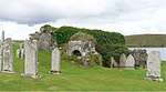 | |||
| Hamnavoe, St Magnus (South Yell) Kirk (Church Of Scotland), Including Graveyard Walls And Post Box | 60°30′15″N 1°06′05″W / 60.504083°N 1.101385°W | Category B | 18678 | | |||
| Greenbank, Braeside Old School, Including Wall | 60°42′47″N 1°01′33″W / 60.713102°N 1.025886°W | Category C(S) | 45318 | | |||
| West Yell, West Yell Schoolhouse, Including Playground And Garden Walls, And Toilet Buildings | 60°31′33″N 1°10′26″W / 60.525868°N 1.173985°W | Category C(S) | 45325 | | |||
| Windhouse, Including Terrace And Garden Walls, And Ha-Ha | 60°36′27″N 1°06′33″W / 60.607616°N 1.109121°W | Category C(S) | 45326 | 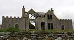 | |||
| Burravoe, Manor House, Including Steps, Outbuilding, Boathouse, Pier, Noost And Slip, Entrance Gates, And Gatepiers, Boundary, Garden And Sea Walls, | 60°29′44″N 1°02′52″W / 60.495667°N 1.047868°W | Category C(S) | 45311 | | |||
| Camb, Seafield, Including Garden Walls | 60°36′39″N 1°04′06″W / 60.610741°N 1.068282°W | Category C(S) | 45315 | | |||
| Mid Yell, Haa Of Gardie, Including Ancillary Structures And Walls | 60°36′12″N 1°04′24″W / 60.603278°N 1.073227°W | Category C(S) | 45322 | | |||
| Windhouse Farmhouse, Steading And Mill, Including W Barn | 60°36′28″N 1°06′16″W / 60.607718°N 1.104315°W | Category B | 45328 | | |||
| Gloup, Gloup Haa, Including Garden Wall | 60°43′16″N 1°04′22″W / 60.72122°N 1.072912°W | Category B | 18653 | | |||
| Burravoe, St Colman's Episcopal Church | 60°29′54″N 1°03′16″W / 60.498445°N 1.054576°W | Category B | 18681 | | |||
| Burravoe, Shop And Former Booth | 60°29′41″N 1°03′20″W / 60.4946°N 1.055671°W | Category C(S) | 45312 | | |||
| Sellafirth, Sellafirth Kirk, Including Churchyard Wall And Gatepiers | 60°39′59″N 1°03′24″W / 60.66649°N 1.056773°W | Category C(S) | 45324 | | |||
| Cullivoe, St Olaf's (North Yell) Kirk (Church Of Scotland), Including Boundary Wall And Gatepiers | 60°41′57″N 1°00′18″W / 60.699248°N 1.005112°W | Category C(S) | 18649 | | |||
| Breakon, Sandwater Mills | 60°43′20″N 1°02′27″W / 60.722323°N 1.040876°W | Category C(S) | 18652 | | |||
| Gutcher, Telephone Kiosk | 60°40′21″N 0°59′54″W / 60.672476°N 0.998197°W | Category B | 45319 | | |||
| Mid Yell, Gardiestaing, Including Outbuildings | 60°36′13″N 1°04′04″W / 60.603724°N 1.067662°W | Category C(S) | 45321 | | |||
| West Sandwick, North Haa (West Sandwick House), Including Garden Walls, Gates And Gatepiers, Walled Garden, And Pier | 60°34′22″N 1°11′20″W / 60.572774°N 1.188917°W | Category A | 18648 | | |||
| Burravoe, Telephone Kiosk | 60°29′41″N 1°03′21″W / 60.494629°N 1.05587°W | Category B | 45313 | | |||
| Camb, Rooms O' Seafield, Including Store And Wall | 60°36′39″N 1°04′07″W / 60.610842°N 1.068663°W | Category C(S) | 45314 | | |||
| Sellafirth, Dalsetter Haa, Including Outbuilding | 60°40′16″N 1°04′23″W / 60.671139°N 1.073163°W | Category C(S) | 45323 | | |||
| Mid Yell, Linkshouse | 60°35′51″N 1°03′32″W / 60.597602°N 1.058855°W | Category C(S) | 18986 | | |||
| Ulsta, Pier House | 60°29′49″N 1°09′32″W / 60.49697°N 1.158975°W | Category C(S) | 18679 | | |||
| Kirkabister, Sheep Pund | 60°38′22″N 1°00′54″W / 60.63954°N 1.014942°W | Category B | 45320 | | |||
| Greenbank, Greenbank House, Including Shop, Outbuilding, Garden Walls And Piers, And Boundary Walls | 60°42′58″N 1°00′52″W / 60.716027°N 1.014582°W | Category B | 18651 | |
Key
The scheme for classifying buildings in Scotland is:
- Category A: "buildings of national or international importance, either architectural or historic; or fine, little-altered examples of some particular period, style or building type."[1]
- Category B: "buildings of regional or more than local importance; or major examples of some particular period, style or building type, which may have been altered."[1]
- Category C: "buildings of local importance; lesser examples of any period, style, or building type, as originally constructed or moderately altered; and simple traditional buildings which group well with other listed buildings."[1]
In March 2016 there were 47,288 listed buildings in Scotland. Of these, 8 per cent were Category A, and 50 per cent were Category B, with the rest listed at Category C.[2]
Notes
- ↑ Sometimes known as OSGB36, the grid reference (where provided) is based on the British national grid reference system used by the Ordnance Survey.
• "Guide to National Grid". Ordnance Survey. Retrieved 2007-12-12.
• "Get-a-map". Ordnance Survey. Retrieved 2007-12-17. - ↑ The "HB Number" is a unique number assigned to each listed building by Historic Environment Scotland.
References
- All entries, addresses and coordinates are based on data from Historic Scotland. This data falls under the Open Government Licence
- 1 2 3 "What is Listing?". Historic Environment Scotland. Retrieved 29 May 2018.
- ↑ Scotland's Historic Environment Audit 2016 (PDF). Historic Environment Scotland and the Built Environment Forum Scotland. pp. 15–16. Retrieved 29 May 2018.
This article is issued from
Wikipedia.
The text is licensed under Creative Commons - Attribution - Sharealike.
Additional terms may apply for the media files.