| Name |
Location |
Date Listed |
Grid Ref. [note 1] |
Geo-coordinates |
Notes |
HB Number [note 2] |
Image |
| Bogensourie Cottage |
|
|
|
57°36′09″N 2°05′46″W / 57.602433°N 2.096013°W / 57.602433; -2.096013 (Bogensourie Cottage) |
Category B |
16539 |

|
| 23, 25 Water Street |
|
|
|
57°35′13″N 2°05′36″W / 57.586814°N 2.093295°W / 57.586814; -2.093295 (23, 25 Water Street) |
Category C(S) |
16556 |
|
| All Saints' Episcopal Church, Hall And Schoolhouse, North Street |
|
|
|
57°35′19″N 2°05′31″W / 57.588531°N 2.092079°W / 57.588531; -2.092079 (All Saints' Episcopal Church, Hall And Schoolhouse, North Street) |
Category C(S) |
16562 |
|
| 2 North Street |
|
|
|
57°35′10″N 2°05′17″W / 57.586207°N 2.088159°W / 57.586207; -2.088159 (2 North Street) |
Category C(S) |
16564 |
|
| Northcote, North Street |
|
|
|
57°35′09″N 2°05′25″W / 57.585909°N 2.090299°W / 57.585909; -2.090299 (Northcote, North Street) |
Category B |
16565 |
|
| Original Parish Church Of Strichen, South Aisle |
|
|
|
57°34′58″N 2°05′24″W / 57.582757°N 2.089957°W / 57.582757; -2.089957 (Original Parish Church Of Strichen, South Aisle) |
Category B |
16569 |
|
| Hunter's Lodge, Mormond Hill |
|
|
|
57°36′05″N 2°03′42″W / 57.601358°N 2.061559°W / 57.601358; -2.061559 (Hunter's Lodge, Mormond Hill) |
Category C(S) |
16541 |
|
| 75, 77 High Street Strichen |
|
|
|
57°35′15″N 2°05′31″W / 57.587507°N 2.091859°W / 57.587507; -2.091859 (75, 77 High Street Strichen) |
Category C(S) |
16552 |
|
| Anderson And Woodman Institute, Water Street |
|
|
|
57°35′18″N 2°05′41″W / 57.588304°N 2.094604°W / 57.588304; -2.094604 (Anderson And Woodman Institute, Water Street) |
Category B |
16558 |
|
| Former Parish Church Of Strichen |
|
|
|
57°34′57″N 2°05′25″W / 57.582424°N 2.090207°W / 57.582424; -2.090207 (Former Parish Church Of Strichen) |
Category C(S) |
16570 |
|
| Old Bridge Over Ugie Water At Mill Of Strichen |
|
|
|
57°35′19″N 2°05′46″W / 57.588744°N 2.095993°W / 57.588744; -2.095993 (Old Bridge Over Ugie Water At Mill Of Strichen) |
Category B |
16568 |
|
| Old Parish Church Graveyard |
|
|
|
57°34′57″N 2°05′24″W / 57.582631°N 2.090074°W / 57.582631; -2.090074 (Old Parish Church Graveyard) |
Category C(S) |
16571 |
|
| Techmuiry House And Offices |
|
|
|
57°37′51″N 2°04′20″W / 57.630931°N 2.072343°W / 57.630931; -2.072343 (Techmuiry House And Offices) |
Category B |
16540 |
|
| Howford, Old Farmhouse |
|
|
|
57°35′00″N 2°04′45″W / 57.583195°N 2.079238°W / 57.583195; -2.079238 (Howford, Old Farmhouse) |
Category C(S) |
16543 |
|
| Strichen House, Doocot |
|
|
|
57°34′48″N 2°06′25″W / 57.579914°N 2.106873°W / 57.579914; -2.106873 (Strichen House, Doocot) |
Category B |
16548 |
|
| Mormond Hotel, Water Street At W. Corner With Bridge Street |
|
|
|
57°35′09″N 2°05′33″W / 57.585755°N 2.092406°W / 57.585755; -2.092406 (Mormond Hotel, Water Street At W. Corner With Bridge Street) |
Category C(S) |
16559 |
|
| Adziel House |
|
|
|
57°34′08″N 2°05′25″W / 57.56896°N 2.090174°W / 57.56896; -2.090174 (Adziel House) |
Category C(S) |
16545 |
|
| New Leeds Church And Manse (Now Mrs. Smith) |
|
|
|
57°34′48″N 2°00′32″W / 57.579968°N 2.008882°W / 57.579968; -2.008882 (New Leeds Church And Manse (Now Mrs. Smith)) |
Category B |
16546 |
|
| Strichen House, Kennels Cottage |
|
|
|
57°34′42″N 2°06′55″W / 57.578308°N 2.115329°W / 57.578308; -2.115329 (Strichen House, Kennels Cottage) |
Category B |
16549 |
|
| Bridge Over North Ugie Water On B 9093 |
|
|
|
57°35′21″N 2°05′46″W / 57.589139°N 2.096178°W / 57.589139; -2.096178 (Bridge Over North Ugie Water On B 9093) |
Category C(S) |
16567 |
|
| Mill Of Strichen |
|
|
|
57°35′19″N 2°05′46″W / 57.588618°N 2.096193°W / 57.588618; -2.096193 (Mill Of Strichen) |
Category B |
16538 |
|
| Burnshangie Farmhouse And Walled Garden |
|
|
|
57°35′20″N 2°05′02″W / 57.588842°N 2.0839°W / 57.588842; -2.0839 (Burnshangie Farmhouse And Walled Garden) |
Category B |
16542 |
|
| Strichen House, Stableblock, (Barnyards Of Strichen) Strichen Mains |
|
|
|
57°34′34″N 2°06′25″W / 57.576115°N 2.106878°W / 57.576115; -2.106878 (Strichen House, Stableblock, (Barnyards Of Strichen) Strichen Mains) |
Category B |
16547 |
|
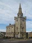
| Town House High Street And Bridge Street |
|
|
|
57°35′11″N 2°05′27″W / 57.586475°N 2.090836°W / 57.586475; -2.090836 (Town House High Street And Bridge Street) |
Category A |
16551 |
 Upload another image
|
| 40, 42 North Street |
|
|
|
57°35′16″N 2°05′26″W / 57.58767°N 2.090554°W / 57.58767; -2.090554 (40, 42 North Street) |
Category C(S) |
16563 |
|
| Manse Of Strichen |
|
|
|
57°34′38″N 2°05′27″W / 57.577304°N 2.090763°W / 57.577304; -2.090763 (Manse Of Strichen) |
Category C(S) |
16572 |
|
| Dairy (Gordon) High Street |
|
|
|
57°35′16″N 2°05′37″W / 57.587703°N 2.093649°W / 57.587703; -2.093649 (Dairy (Gordon) High Street) |
Category C(S) |
16555 |
|
| 25 Bridge Street And S. Gibson's Shop |
|
|
|
57°35′10″N 2°05′28″W / 57.586026°N 2.091069°W / 57.586026; -2.091069 (25 Bridge Street And S. Gibson's Shop) |
Category C(S) |
16560 |
|
| All Saint's Episcopal Church, West Street |
|
|
|
57°35′19″N 2°05′32″W / 57.58854°N 2.092296°W / 57.58854; -2.092296 (All Saint's Episcopal Church, West Street) |
Category C(S) |
16561 |
|
| Bridge Over North Ugie Water (A 981) At S.W. End Of Bridge Street |
|
|
|
57°35′07″N 2°05′33″W / 57.585342°N 2.092606°W / 57.585342; -2.092606 (Bridge Over North Ugie Water (A 981) At S.W. End Of Bridge Street) |
Category C(S) |
16566 |
|
| "Roman" Bridge, Howford, Over North Ugie Water |
|
|
|
57°34′54″N 2°04′47″W / 57.581758°N 2.07982°W / 57.581758; -2.07982 ("Roman" Bridge, Howford, Over North Ugie Water) |
Category C(S) |
16544 |
|
| Mart House Market Street |
|
|
|
57°35′09″N 2°05′25″W / 57.585909°N 2.090299°W / 57.585909; -2.090299 (Mart House Market Street) |
Category B |
16550 |
|
| Holmwood, High Street |
|
|
|
57°35′20″N 2°05′39″W / 57.58879°N 2.09407°W / 57.58879; -2.09407 (Holmwood, High Street) |
Category B |
16554 |
|
| Library House, Water Street |
|
|
|
57°35′17″N 2°05′40″W / 57.588179°N 2.094486°W / 57.588179; -2.094486 (Library House, Water Street) |
Category B |
16557 |
|