List of listed buildings in Rothes, Moray
This is a list of listed buildings in the parish of Rothes in Moray, Scotland.
List
| Name | Location | Date Listed | Grid Ref. [note 1] | Geo-coordinates | Notes | HB Number [note 2] | Image |
|---|---|---|---|---|---|---|---|
| Glebe House (Former Free Church Manse) And Garden Walls | 24 Mar 1988 | 57°31′10″N 3°12′36″W / 57.519463°N 3.210109°W | Category B | 40439 |  | ||
| Orton House, Dovecot | 26 Jan 1971 | 57°33′52″N 3°08′45″W / 57.564485°N 3.14584°W | Category B | 15829 | 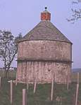 | ||
| Orton, West Lodge | 9 Nov 1987 | 57°34′16″N 3°09′11″W / 57.571021°N 3.153068°W | Category C(S) | 15830 | | ||
| Boat O' Brig Railway Viaduct Over River Spey | 9 Nov 1987 | 57°33′04″N 3°08′24″W / 57.55107°N 3.140138°W | Category B | 15849 | 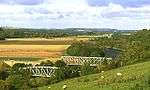 | ||
| Orton, Mausoleum, Enclosing Burial Ground Walls And St Mary's Well | 9 Nov 1987 | 57°34′54″N 3°07′58″W / 57.581617°N 3.132698°W | Category B | 15867 | 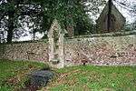 | ||
| Rothes Glen Hotel (Formerly Birchfield) | 9 Nov 1987 | 57°33′26″N 3°14′51″W / 57.557315°N 3.247364°W | Category B | 15871 | | ||
| 8, 10, 12, 14, 16, High Street | 24 Mar 1988 | 57°31′36″N 3°12′28″W / 57.526708°N 3.207727°W | Category B | 40443 | | ||
| Orton, Roo Emah And Marwin (Former Railway Houses And Station | 9 Nov 1987 | 57°33′41″N 3°09′06″W / 57.561467°N 3.151629°W | Category B | 15870 | | ||
| High Street/Seafield Square, Rothes Parish Church (Church Of Scotland) | 26 Jan 1971 | 57°31′37″N 3°12′27″W / 57.526899°N 3.2075°W | Category B | 40440 | | ||
| 67 New Street | 24 Mar 1988 | 57°31′47″N 3°12′29″W / 57.529697°N 3.208026°W | Category B | 40444 | | ||
| Dundurcas Old Church And Burial Ground | 9 Nov 1987 | 57°32′39″N 3°10′02″W / 57.544122°N 3.167104°W | Category B | 15827 | 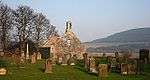 | ||
| Orton House | 26 Jan 1971 | 57°34′13″N 3°08′53″W / 57.570311°N 3.14818°W | Category B | 15828 | 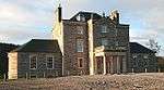 | ||
| Rothes Glen, Brylach (Former Stable/Carriage House) | 9 Nov 1987 | 57°33′19″N 3°14′52″W / 57.555245°N 3.247711°W | Category B | 15850 | | ||
| Rothes Glen, Kennels Lodge | 9 Nov 1987 | 57°33′16″N 3°14′44″W / 57.554431°N 3.245611°W | Category C(S) | 15851 | | ||
| Speyburn Distillery, Malt-Barn And Malt Kiln | 9 Nov 1987 | 57°32′11″N 3°12′57″W / 57.536269°N 3.215827°W | Category B | 15852 | 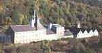 | ||
| The Grange (Former Church Of Scotland Manse) And Garden Walls | 24 Mar 1988 | 57°31′39″N 3°12′38″W / 57.527544°N 3.21051°W | Category C(S) | 40438 | | ||
| Off High Street, Kirk Place, Land Farm Barn/Store | 24 Mar 1988 | 57°31′36″N 3°12′25″W / 57.526769°N 3.206994°W | Category B | 40441 | | ||
| Auchinroath Bridge Over Millstoneford Burn | 9 Nov 1987 | 57°32′47″N 3°13′35″W / 57.546507°N 3.226377°W | Category C(S) | 15848 | | ||
| Orton, St Mary's | 9 Nov 1987 | 57°34′59″N 3°08′03″W / 57.583186°N 3.134085°W | Category C(S) | 15868 | | ||
| Orton, Chapel Cottage (Formerly St Mary's Cottage) | 9 Nov 1987 | 57°34′52″N 3°08′16″W / 57.580987°N 3.13788°W | Category B | 15869 | | ||
| 6 High Street | 24 Mar 1988 | 57°31′36″N 3°12′28″W / 57.526762°N 3.207679°W | Category B | 40442 | | ||
| Orton, Farm Home Steading (Excluding Cottages) | 9 Nov 1987 | NJ 31257 54045 | 57°34′16″N 3°09′03″W / 57.57122°N 3.150934°W | Category C(S) | 15831 | 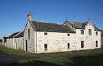 |
Key
The scheme for classifying buildings in Scotland is:
- Category A: "buildings of national or international importance, either architectural or historic; or fine, little-altered examples of some particular period, style or building type."[1]
- Category B: "buildings of regional or more than local importance; or major examples of some particular period, style or building type, which may have been altered."[1]
- Category C: "buildings of local importance; lesser examples of any period, style, or building type, as originally constructed or moderately altered; and simple traditional buildings which group well with other listed buildings."[1]
In March 2016 there were 47,288 listed buildings in Scotland. Of these, 8 per cent were Category A, and 50 per cent were Category B, with the rest listed at Category C.[2]
See also
Notes
- ↑ Sometimes known as OSGB36, the grid reference (where provided) is based on the British national grid reference system used by the Ordnance Survey.
• "Guide to National Grid". Ordnance Survey. Retrieved 2007-12-12.
• "Get-a-map". Ordnance Survey. Retrieved 2007-12-17. - ↑ The "HB Number" is a unique number assigned to each listed building by Historic Environment Scotland.
References
- All entries, addresses and coordinates are based on data from Historic Scotland. This data falls under the Open Government Licence
- 1 2 3 "What is Listing?". Historic Environment Scotland. Retrieved 29 May 2018.
- ↑ Scotland's Historic Environment Audit 2016 (PDF). Historic Environment Scotland and the Built Environment Forum Scotland. pp. 15–16. Retrieved 29 May 2018.
This article is issued from
Wikipedia.
The text is licensed under Creative Commons - Attribution - Sharealike.
Additional terms may apply for the media files.