List
| Name |
Location |
Date Listed |
Grid Ref. [note 1] |
Geo-coordinates |
Notes |
HB Number [note 2] |
Image |
| Lathallan House, Ivy Cottage |
|
|
|
55°58′59″N 3°40′46″W / 55.983024°N 3.679361°W / 55.983024; -3.679361 (Lathallan House, Ivy Cottage) |
Category C(S) |
49524 |

|
| Linlithgow Bridge, Glenavon House |
|
|
|
55°58′43″N 3°37′58″W / 55.978692°N 3.632646°W / 55.978692; -3.632646 (Linlithgow Bridge, Glenavon House) |
Category B |
50804 |
|
| Dovecot, Muiravonside House |
|
|
|
55°57′36″N 3°39′31″W / 55.960058°N 3.658662°W / 55.960058; -3.658662 (Dovecot, Muiravonside House) |
Category B |
15322 |
.jpg) Upload another image
|
| Manuel Nunnery |
|
|
|
55°58′11″N 3°38′56″W / 55.969653°N 3.648785°W / 55.969653; -3.648785 (Manuel Nunnery) |
Category B |
13848 |
|
| Vellore House |
|
|
|
55°58′19″N 3°41′03″W / 55.971977°N 3.684202°W / 55.971977; -3.684202 (Vellore House) |
Category B |
19204 |
|
| Cottages And Public House, Linlithgow Bridge |
|
|
|
55°58′37″N 3°37′53″W / 55.976867°N 3.631335°W / 55.976867; -3.631335 (Cottages And Public House, Linlithgow Bridge) |
Category B |
15325 |
|
| Compston |
|
|
|
55°57′54″N 3°40′17″W / 55.964935°N 3.671479°W / 55.964935; -3.671479 (Compston) |
Category C(S) |
15327 |
|
| Lathallan House, Power House |
|
|
|
55°59′02″N 3°40′33″W / 55.983943°N 3.675906°W / 55.983943; -3.675906 (Lathallan House, Power House) |
Category B |
49526 |
|
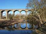
| Avon Viaduct |
|
|
|
55°56′07″N 3°42′32″W / 55.935361°N 3.708788°W / 55.935361; -3.708788 (Avon Viaduct) |
Category A |
15326 |
 Upload another image
|
| Canal Bridge Near Causewayend |
|
|
|
55°57′58″N 3°39′48″W / 55.966076°N 3.66347°W / 55.966076; -3.66347 (Canal Bridge Near Causewayend) |
Category C(S) |
15319 |
|
| Avon Aqueduct |
|
|
|
55°57′51″N 3°39′22″W / 55.964173°N 3.655986°W / 55.964173; -3.655986 (Avon Aqueduct) |
Category A |
15321 |
 Upload another image
|
| Candie House |
|
|
|
55°56′57″N 3°42′24″W / 55.949077°N 3.706669°W / 55.949077; -3.706669 (Candie House) |
Category B |
15323 |
|
| Lathallan House |
|
|
|
55°59′00″N 3°40′48″W / 55.983322°N 3.679919°W / 55.983322; -3.679919 (Lathallan House) |
Category B |
49523 |
|
| Manuel House |
|
|
|
55°58′04″N 3°39′13″W / 55.967754°N 3.653688°W / 55.967754; -3.653688 (Manuel House) |
Category B |
19392 |
|
| Parish Church Muiravonside |
|
|
|
55°58′27″N 3°40′29″W / 55.97428°N 3.674767°W / 55.97428; -3.674767 (Parish Church Muiravonside) |
Category B |
15313 |
|
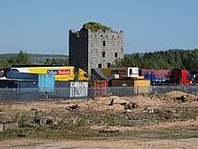
| Almond Castle |
|
|
|
55°58′38″N 3°40′25″W / 55.977163°N 3.673561°W / 55.977163; -3.673561 (Almond Castle) |
Category B |
15314 |
 Upload another image
|
| The Haining (Formerly Parkhall) |
|
|
|
55°58′34″N 3°41′18″W / 55.976171°N 3.688311°W / 55.976171; -3.688311 (The Haining (Formerly Parkhall)) |
Category B |
15315 |
|
| House, Manuel Mill |
|
|
|
55°58′05″N 3°39′03″W / 55.967946°N 3.650716°W / 55.967946; -3.650716 (House, Manuel Mill) |
Category B |
15320 |
|
| Railway Viaduct Avonbank |
|
|
|
55°59′20″N 3°39′24″W / 55.988787°N 3.656574°W / 55.988787; -3.656574 (Railway Viaduct Avonbank) |
Category B |
15329 |
|
| Lathallan House, Walled Garden |
|
|
|
55°59′00″N 3°40′36″W / 55.983251°N 3.676565°W / 55.983251; -3.676565 (Lathallan House, Walled Garden) |
Category B |
49525 |
|
| Manuel Mill |
|
|
|
55°58′03″N 3°39′03″W / 55.967542°N 3.650698°W / 55.967542; -3.650698 (Manuel Mill) |
Category B |
19264 |
|
| Torphichen Bridge |
|
|
|
55°56′38″N 3°40′31″W / 55.943783°N 3.675308°W / 55.943783; -3.675308 (Torphichen Bridge) |
Category C(S) |
15324 |
|
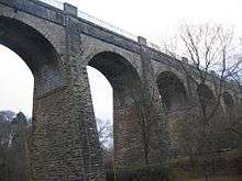
| Westfield Railway Viaduct |
|
|
|
55°56′07″N 3°42′32″W / 55.935361°N 3.708788°W / 55.935361; -3.708788 (Westfield Railway Viaduct) |
Category B |
15328 |
|
Key
The scheme for classifying buildings in Scotland is:
- Category A: "buildings of national or international importance, either architectural or historic; or fine, little-altered examples of some particular period, style or building type."[1]
- Category B: "buildings of regional or more than local importance; or major examples of some particular period, style or building type, which may have been altered."[1]
- Category C: "buildings of local importance; lesser examples of any period, style, or building type, as originally constructed or moderately altered; and simple traditional buildings which group well with other listed buildings."[1]
In March 2016 there were 47,288 listed buildings in Scotland. Of these, 8 per cent were Category A, and 50 per cent were Category B, with the rest listed at Category C.[2]